Blythe, California - from
Wikipedia
Blythe is a city in Riverside County, California, United
States, in the Palo Verde Valley of the Lower Colorado River Valley region,
an agricultural area and part of the Colorado Desert along the Colorado
River, approximately 224 miles (360 km) east of Los Angeles and 150 miles
(240 km) west of Phoenix. Blythe was named after Thomas H. Blythe, a San
Francisco financier, who established primary water rights to the Colorado
River in the region in 1877. The city was incorporated on July 21, 1916.
The population was 20,817 at the 2010 census.
History
In the early or mid-1870s, William Calloway (known as
Oliver Calloway in some sources), an engineer and a former captain of the
1st California Infantry Regiment, explored an area across the Colorado
River from Ehrenberg, Arizona and found its potential for development.
Calloway made preliminary surveys and filed land claims under the Swamp
Land Act of 1850. He interested the wealthier Thomas Henry Blythe (real
last name Williams), who was born in Mold, Wales, to
undertake development and settlement of an "empire" located
next to the Colorado.
|
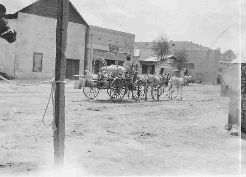
Blythe street scene 1900
|
On July 17, 1877, Blythe filed his first claim for Colorado
River water on what was to become the "Blythe Intake". Blythe appointed
another man named George Irish as manager to assist Calloway in building
an irrigation system. Calloway died in a Chemehuevi attack in March 28,
1880, and was replaced by C.C. Miller, the father of Frank Augustus Miller.
Thomas Blythe died on April 4, 1883; his only revisit to the valley was
in November 1882. After his death, the work in the valley halted and Blythe's
estate subsequently went into litigation between his illegitimate daughter
Florence and other claimants, the trial beginning on 1889. By the 1900s,
Florence was awarded the estate, after several years of preceding rulings
in favor of her and appeals against her.
Frank Murphy and Ed Williams, who were involved on the
cattle industry in southeastern Arizona, came to the area in 1904 and were
convinced it was well-suited for cattle and farming. With the Hobson brothers
from Ventura County, they bought Blythe's estate and formed the Palo Verde
Land and Water Company. During 19111912, W.F. Holt, who helped develop
nearby Imperial Valley, was the company's general manager.
On August 8, 1916, the California Southern Railroad reached
Blythe from the desert station of Rice, then known as Blythe Junction.
It was later renamed to honor G.W. Rice, an engineer and superintendent
of the railroad. The dramatic growth in the valley following this event
attracted national attention. Production totals increased annually from
virtually nothing to near $8,000,000 in few years, primarily from cotton
and cotton seed shipped to the ports. The lower cotton prices in 1920 ended
this prosperous time. The Atchison, Topeka and Santa Fe Railway began leasing
the line in 1921 and acquired it in the end of 1942.
In 1935, the completion of Boulder Dam extinguished the
destructive annual floods in the valley. As noted in the city's fiftieth
anniversary, some forty crops were grown in the farms, and large cattle
feeds were another aspect of the agriculture industry. Nearly two decades
earlier, the Fisher ranch had the biggest herd of registered Brahman cattle
in California, the breeding stock having been sold to western states and
other countries.
During World War II, Blythe was the site of United States
Army Air Forces facilities in the Blythe Airport and the Gary Field.
The first automobile bridge over the Colorado River between
Blythe and Ehrenberg was constructed in 1928 to replace a cable ferry service.
The bridge's successor was built in the early 1960s and it was expanded
to four lanes and a pedestrian walkway in early 1974.
In 1972, Interstate 10 was built through the city, replacing
US 60 and the previously decommissioned US 70 in Hobsonway as the main
thoroughfare.
In 2016, the voter-approved recreational use of cannabis
in California has made the cannabis industry drawn to the economically
declined city due to lower land prices, water, and potentially lower taxes
compared to other parts of the state. One of the proposed cannabis facilities,
Palo Verde Center, would be one of the largest in North America.
Geography and climate
Blythe is located near the California/Arizona border in
the Colorado Desert section of the Sonoran Desert, at the junction of Interstate
10 and US 95. According to the United States Census Bureau, the city has
a total area of 27.0 square miles (70 km2), of which 26.2 square miles
(68 km2) is land and 0.8 square miles (2.1 km2) (2.9%) is water.
Nearby communities include Lost Lake and Vidal to the
north, Ripley to the south, Desert Center to the west, and Ehrenberg, Arizona,
to the east. Major cities in the region include Yuma (85 miles), Indio
(95 miles), Phoenix (150 miles), San Bernardino (170 miles), Riverside
(172 miles), and Las Vegas (200 miles). Blythe is within 4 hours via car
of 10% of the United States' population.
Blythe has a hot desert climate, featuring extremely hot
summers and mild winters. There are an average of 178.4 days with highs
of 90 °F (32 °C) or higher. There are an average of 18.9 days with
lows of 32 °F (0 °C) or lower. Until 2016, the record high temperature
was 122 °F (50 °C) on July 7, 1920, and June 24, 1929. But on June
20, 2016, that long-standing record was shattered when Blythe reached 124
°F (51 °C). The record low temperature was 5 °F (?15 °C)
on January 6, 1913. There are an average of 16 days with measurable precipitation.
The wettest year was 1951 with 8.71 inches (22.1 cm) and the driest year
was 1956 with .18 inches (0.46 cm). The most rainfall in one month was
6.00 inches (15.2 cm) in August 1951, which included the 24-hour record
rainfall of 3.06 inches (7.8 cm) on August 27.[28]
At the airport, there are an average of 176.0 days with
highs of 90 °F (32 °C) or higher. There are an average of 5.4 days
with lows of 32 °F (0 °C) or lower. The record high temperature
was 124 °F (51 °C) on June 20, 2016. The record low temperature
was 20 °F (?7 °C) on January 8, 1971. There an average of 17 days
with measurable precipitation. The wettest year was 1992 with 9.16 inches
(23.3 cm) and the driest year was 1953 with .59 inches (1.5 cm). The most
rainfall in one month was 5.92 inches (15.0 cm) in August 1951, which included
the 24-hour record rainfall of 3.00 inches (7.6 cm) on August 26.
Local features
Tourism is a major component of the local economy. Blythe
is a stopover city with full services for travelers between any of the
nearby regions, in particular the major cities of Los Angeles and Phoenix,
since it is approximately midway between those two metropolitan areas.
The winter months bring visitors avoiding the colder climates of the north,
when the population of the area within 50 miles (80 km) of Blythe has been
known to exceed 500,000.
Con-Way freight has a large facility here. It is used
mainly at night for cross dock operations, as there is seldom a need to
make deliveries here.
Blythe also contains 24 churches, one library, two newspapers
(Palo Verde Valley Times, The Desert Independent), two museums, two radio
stations (KERU-FM [32] and KJMB-FM ), three banks, a three-screen
movie theater (now closed), one funeral home and an 18,500 sq ft (1,720
m2). recreation center. The area is popular with campers and hikers and
has six parks, seven campgrounds, seven RV parks, 3 boat ramps onto the
Colorado River, and an 18-hole public golf course.
Blythe hosts the Blythe Blue Grass Festival annually the
third weekend of January.
Dove hunting is popular in Blythe. The hunting season
starts every September 1.
|
Needles, California - from Wikipedia
Needles (Mojave: ?Aha Kuloh) is a city in San Bernardino
County, California, United States. It lies on the western banks of the
Colorado River in the Mohave Valley subregion of the Mojave Desert, near
the borders of Arizona and Nevada and roughly 110 miles (180 km) from the
Las Vegas Strip. It is the easternmost city of the San Bernardino-Riverside
metropolitan area. Needles is geographically isolated from other cities
in the county. Barstow, the nearest city within the county, is separated
from Needles by over 140 miles of desert and 2 mountain ranges. The city
is accessible via Interstate 40 and U.S. Route 95. The population was 4,844
at the 2010 census, up from 4,830 at the 2000 census.
Needles was named after "The Needles", a group of pinnacles
in the Mohave Mountains on the Arizona side of the river to the south of
the city. The large Mohave Native American community shares the nearby
Fort Mojave Indian Reservation and the town. Needles is a gateway to the
Mojave National Preserve.
History
The Mohave, one of the traditional Colorado River Indian
Tribes, are Native Americans that have been living in the Mojave Valley
area for thousands of years prior to the European exploration of the area.
In the Mohave language, they call themselves the ?Aha Makhav. Their name
comes from two words: ?aha, meaning "river", and makhav, meaning "along"
or "beside", and to them it means "people who live along the river". These
people traded with the tribes of coastal Southern California following
the Mohave Trail. The Franciscan missionary Francisco Garcés, was
the first European to visit the Mohave people and travel on the trail and
report on the route in 1776. From 1829 to 1848, part of this trail became
a part of the route of the Old Spanish Trail between New Mexico and Southern
California.
The historic Mojave Road, now goes through the Mojave
National Preserve, essentially following the route of the Mohave Trail.
Along it, in 1859, Fort Mohave was built and the road established to protect
new pioneer immigrants to California from New Mexico and other travelers
from the Mohave during the Mohave War.
The city was founded in May 1883 as a result of the construction
of the Atchison, Topeka and Santa Fe Railway, which originally crossed
the Colorado River at Eastbridge, Arizona three miles southeast of modern
downtown Needles. The name was derived from the Needles, pointed mountain
peaks at the south end of the valley with wind-blown holes in them, visible
only by boat from the Colorado River. This point on the Colorado River
was a poor site for such a bridge, lacking firm banks and a solid bottom.
Additionally, the bridge was not of the best quality, which led to criticism
that it was a "flimsy looking structure", and was an obstruction to navigation,
since it lacked a draw to allow boat traffic. The flooding and meandering
of the Colorado River destroyed the bridge in 1884, 1886 and 1888. Finally,
the railroad surrendered to nature and built the Red Rock Bridge, a high
cantilever bridge, at a much narrower point with solid rock footings ten
miles downstream near modern Topock. The bridge was completed in May 1890.
Originally a tent town for railroad construction crews,
the railroad company built a hotel, car sheds, shops and a roundhouse.
Within a month the town also boasted a Chinese wash-house, a newsstand,
a restaurant, a couple of general stores, and nine or ten saloons. The
town became the largest port on the river above Yuma, Arizona. The railway
and the Fred Harvey Company built the elegant Neoclassical and Beaux-Arts
style El Garces Hotel and Santa Fe Station in 1908, which was considered
the "crown jewel" of the entire Fred Harvey chain. The landmark building
is on the National Register of Historic Places and is being restored.
Needles was a major stop on the historic U.S. Route 66
highway from the 1920s through the 1960s. For immigrants from the Midwest
Dust Bowl in the 1930s, it was the first town that marked their arrival
in California. The city is lined with motels and other shops from that
era. The "Carty's Camp", which appears briefly in The Grapes of Wrath as
the Joad family enters California from Arizona, is now a ghost tourist
court, its remains located behind the 1940s-era 66 Motel.
In 1949, the United States Bureau of Reclamation began
an extensive project to dredge a new channel for the Colorado River that
would straighten out a river bend that was causing serious silt problems
since the Hoover Dam was completed.
Needles is a tourism and recreation center, a tradition
going back many decades. The city is the eastern gateway to the Mojave
National Preserve, a scenic desert area.
Geography
Climate
The city has a desert climate with a subtropical temperature
range, with a mean annual temperature of 74.2 °F (23.4 °C)..
Needles, like Death Valley to the northwest, is known
for extreme heat during the summer. The Needles weather station is frequently
reported by the United States government's National Oceanic and Atmospheric
Administration (NOAA) as the site of the highest daily temperature recorded
in the U.S. during the desert summers. Needles occasionally sets national
or world daily temperature records, along with other related records associated
with extreme desert heat. For instance, on July 22, 2006, Needles experienced
a record high low temperature of 100 °F (38 °C) at 6:00 AM with
a high temperature exceeding 120 °F (49 °C), making it one of the
few locations on Earth that have recorded a triple-digit overnight low
temperature. Also, on August 13, 2012, Needles experienced a thunderstorm
that deposited rain at a temperature of 115 °F (46 °C) starting
at 3:56 PM, setting a new record for the hottest rain in world history.
The air temperature was 118 °F (48 °C), tying Needles' record high
for the date. Since the humidity was only 11%, the rain evaporated so that
"only a trace of precipitation was recorded in the rain gauge". Weather
records researcher Maximiliano Herrera reported that this was the lowest
humidity at which rain has occurred on Earth in recorded history. Later,
on May 4, 2014, Needles reached a temperature of 102 °F (39 °C)
with a dewpoint of ?38 °F (?39 °C), for a relative humidity of
0.33%, the lowest value ever recorded on Earth.
In the winter, the normal high temperatures range from
62 °F (17 °C) to 80 °F (27 °C) with lows of 40 °F (4
°C) to 60 °F (16 °C). During summer the normal high temperatures
range from 106 °F (41 °C) to 122 °F (50 °C) with lows of
82 °F (28 °C) to 94 °F (34 °C). The record low temperature
was 20 °F (?7 °C) on December 23, 1990. The average year has 168.4
days with highs of 90 °F (32 °C) or higher and 4.9 days with lows
of 32 °F (0 °C) or lower. On June 20, 2017, the high temperature
record was tied with a reading of 125 °F (52 °C).
Annual rainfall is about 5.11 inches (130 mm). There are
normally 23 days with measurable precipitation. The wettest year was 1965
with 9.50 inches and the driest year was 2006 with 0.70 inches. The most
rainfall in one month was 4.72 inches in September 1976. The most rainfall
in 24 hours was 2.55 inches on August 28, 1951. Although snowfall is very
rare in Needles, 15.2 inches of snow fell in January 1949, including 12.2
inches on January 12, 1949. The city is also known for moderate to locally
severe thunderstorms during the monsoon season as well as humid conditions.
Needles is served by the National Weather Service's NOAA
Weather Radio operating on 162.50 MHz from the Las Vegas National Weather
Service.
|
Parker, Arizona - from Wikipedia
er (Mojave 'Amat Kuhwely, formerly 'Ahwe Nyava) is the
county seat of La Paz County, Arizona, United States, on the Colorado River
in Parker Valley. The population was 3,083 at the 2010 census.
History
Founded in 1908, the town was named after Ely Parker,
the first Native American commissioner for the U.S. government. The original
town site of Parker was surveyed and laid out in 1909 by a railroad location
engineer by the name of Earl. H. Parker for the Arizona & California
Railway. The town officially incorporated in 1948 and became the county
seat for the newly created La Paz county on January 1, 1983.
Camp Colorado and Parkers Landing
The town's name and origin began when a post office called
Parker was established January 6, 1871, at Parker's Landing and the site
of the Parker Indian Agency, named for Ely Parker, on the Colorado River
Indian Reservation, 4 miles down river from the site of the railroad bridge
of the modern town, to serve the Indian agency. What became Parkers Landing
was established on the river as the place to land and pick up cargo and
personnel for the Indian Agency and the U. S. Army detachment that was
stationed there at Camp Colorado from 1864 to 1869 during the first years
of the Reservation. Camp Colorado was abandoned after wind blown sparks
from the departing steamboat Cocopah rapidly burned down the brush huts
of the officers of the garrison, and endangered its barracks and storehouses.
Geography
The city is on the Colorado River just south of the Headgate
Rock Dam and Moovalya Lake. Arizona State Route 95 and California State
Route 62 (across the Colorado River) serve the city.
According to the United States Census Bureau, the town
has a total area of 22.0 square miles (57 km2), of which, 22.0 square miles
(57 km2) of it is land and 0.05% is water.
According to Census Bureau maps, the town is divided into
two non-contiguous sections; the northern section consists of the original
town and is located in the Colorado River Indian reservation and the southern
section consists of a larger, roughly rectangular section of largely undeveloped
territory. The undeveloped territory consist of extensive unpaved roads.
Of the few that are paved Mohave Road is the most utilized between the
town and the territory. The same road can be taken 15.5 miles south to
the Town of Poston which is noted for its relocation camps for Japanese
Americans during World War II.
|
.
All articles submitted to the "Brimstone
Gazette" are the property of the author, used with their expressed permission.
The Brimstone Pistoleros are not
responsible for any accidents which may occur from use of loading
data, firearms information, or recommendations published on the Brimstone
Pistoleros web site. |
|