Fort Smith, Arkansas - from
Wikipedia
Fort Smith is the second-largest city in Arkansas and
one of the two county seats of Sebastian County. As of the 2010 Census,
the population was 86,209. With an estimated population of 87,443 In 2012,
it is the principal city of the Fort Smith, Arkansas-Oklahoma Metropolitan
Statistical Area, a region of 298,592 residents that encompasses the Arkansas
counties of Crawford, Franklin, and Sebastian, and the Oklahoma counties
of Le Flore and Sequoyah.
Fort Smith has a sister city relationship with Cisterna,
Italy, site of the World War II Battle of Cisterna, fought by United States
Army Rangers commanded by Fort Smith native William O. Darby. The city
also has a mutual friendship-city relationship with Jining, China.
Fort Smith lies on the Arkansas-Oklahoma state border,
situated at the confluence of the Arkansas and Poteau rivers, also known
as Belle Point. Fort Smith was established as a western frontier military
post in 1817, when it was also a center of fur trading. The city developed
there. It became well known as a base for migrants settling of the "Wild
West" and its law enforcement heritage.
In 2007, the city of Fort Smith was selected by the United
States Department of the Interior as the site of the new United States
Marshals Service National Museum.
History
This area was occupied for thousands of years by indigenous
peoples, attracted to the advantageous site near the rivers. They used
the waterways for transportation and trading, and to supply fish and water
for their villages. The French claimed this area as part of their New France
and La Louisiane. Some colonial fur traders traveled the Arkansas and other
rivers to trade with the native American tribes.
The United States acquired this territory and large areas
west of the Mississippi River from France in the Louisiana Purchase (1803).
Soon after, the government sent the Pike Expedition (1806) to explore the
areas along the Arkansas River. The US founded Fort Smith in 1817 as a
military post. It was named after General Thomas Adams Smith (17811844),
who commanded the United States Army Rifle Regiment in 1817, headquartered
near St. Louis. General Smith had ordered Army topographical engineer Stephen
H. Long (17841864) to find a suitable site on the Arkansas River for a
fort. General Smith never visited this town or the forts that bore his
name.
A stockade was built and occupied from 1817 until 1822
by a small troop of regulars commanded by Major William Bradford. A small
settlement began forming around the fort, but the Army abandoned the first
Fort Smith in 1824 and moved 80 miles further west to Fort Gibson. John
Rogers, an Army sutler and land speculator, bought up former government-owned
lands at this site and promoted growth of the new civilian town of Fort
Smith. (Some genealogists claim him as an ancestor to 20th-century Oklahoma
comedian Will Rogers.)
Due to the strategic location of this site, the federal
government re-established a military presence at Fort Smith during the
1830s era of Indian Removal, primarily of tribes from the American Southeast
to west of the Mississippi River in Indian Territory, which is now Oklahoma.
In 1838 the Army moved back into the old military post
near Belle Point, and expanded the base. They used troops to escort Choctaw
and Cherokee, from their ancestral homelands in the Southeast; they were
the last of the tribes to leave. Remnants of the Five Civilized Tribes
remained in the southeast, and their descendants in some cases have reorganized
and been federally recognized. The Cherokee called the forced march the
Trail of Tears, as many of their people and African-American slaves died
along the way. The army enforced the removal of these peoples to the reserved
Indian Territory, where the federal government granted them land. Many
displaced Native Americans fell out of the march and settled in Fort Smith
and adjoining Van Buren, Arkansas on the other side of the river.
The US Army also used Fort Smith as a base during the
Mexican War (1846-1848). As a result, the US acquired large territories
in the Southwest, and later annexed the Republic of Texas, which had been
independent for some years.
Sebastian County was formed in 1851, separated from Crawford
County north of the Arkansas River. In 1858, Fort Smith was designated
as a Division Center of the Butterfield Overland Mail's 7th Division route
across Indian Territory from Fort Smith to Texas and as a junction with
the mail route from Memphis, Tennessee, an important port on the east side
of the Mississippi River.
During the early years of the U.S. Civil War, the fort
was occupied by the Confederate Army. Union troops under General Steele
took control of Fort Smith on September 1, 1863. A small fight occurred
there on July 31, 1864, but the Union army maintained command in the area
until the war ended in 1865. As a result, many refugee slaves, orphans,
Southern Unionists, and others came here to escape the guerrilla warfare
raging in Arkansas, Missouri, and the Border States. The slaves were freed
under the Emancipation Proclamation of January 1863 by President Abraham
Lincoln. Federal troops abandoned the post of Fort Smith for the last time
in 1871. The town continued to thrive despite the absence of federal troops.
Two of Fort Smith's most notable historic figures were
Judge Isaac Parker and William Henry Harrison Clayton, sometimes referred
to as W.H.H. Clayton. In 1874, William Henry Harrison Clayton was appointed
United States Attorney for the Western District of Arkansas by President
Ulysses S. Grant. Fort Smith was a bustling community full of brothels,
saloons and outlaws, just across the river from Indian Territory. William
Clayton realized a strong judge would be necessary to bring law and order
to the region. He knew that Isaac Parker was a strong judge. But Judge
Parker had been appointed Chief Justice of Utah Territory and confirmed
by the US Senate. With the help of President Grant and US Senator Powell
Clayton, former governor of Arkansas, William Clayton was able to gain
the appointment of Judge Parker in the Fort Smith district.
Judge Isaac Parker served as U.S. District Judge 18751896.
He was nicknamed the "Hanging Judge": in his first term after assuming
his post, he tried 18 people for murder, convicted 15 of them, and sentenced
eight of those to die. Six of these men were later hanged on the same day.
Over the course of his career in Fort Smith, Parker sentenced 160 people
to death. Of those, 79 were executed on the gallows. His courthouse is
now marked as a National Historic Site, where "more men were put to death
by the U.S. Government... than in any other place in American history."
William Clayton served as US Attorney under four different
presidents and later was appointed as Chief Justice of Indian Territory.
He was instrumental in achieving statehood for Oklahoma in 1907, after
Native American claims were extinguished by distribution of communal lands
under the Dawes Act and the break up of tribal governments. Together with
Territorial Governor Frank Frantz, Clayton took a copy of the Oklahoma
Constitution to President Theodore Roosevelt after the state was admitted
to the Union in 1907. Governor Frantz and Judge Clayton both lost their
territorial positions when Oklahoma became a state; a new governor was
elected and the Roosevelt administration appointed a new judge.
During investment in the military prior to World War
II, the Army returned to Fort Smith in 1941. It established the Fort Chaffee
Military Reservation east of the city.
On April 21, 1996, a large tornado, part of the April
1996 Tornado Outbreak Sequence, destroyed and heavily damaged much of historic
downtown Fort Smith around the Garrison Avenue Bridge. The storm tracked
from eastern Pittsburg County, Oklahoma into Fort Smith and Van Buren,
Arkansas. The tornado left four people dead in western Arkansas. Days later,
the damaged Eads Brothers Furniture building in downtown Fort Smith was
destroyed by one of the largest fires in the city's history.
Geography
According to the United States Census Bureau, the city
has a total area of 64.6 square miles (167 km2), of which, 61.7 square
miles (160 km2) of it is land and 3.9 square miles (10 km2) of it (6.3%)
is water.
|
Fort Gibson, Oklahoma - from
Wikipedia
Fort Gibson is a historic military site located next
to the present day city of Fort Gibson, in Muskogee County Oklahoma. It
guarded the American frontier in Indian Territory from 1824 until 1888.
When constructed, the fort lay farther west than any other military post
in the United States; it formed part of the northsouth chain of forts
intended to maintain peace on the frontier of the American West and to
protect the southwestern border of the Louisiana Purchase. The fort succeeded
in its peacekeeping mission for more than 50 years, as no massacres or
battles occurred there The fort site is now managed by the Oklahoma Historical
Society as the Fort Gibson Historical Site. It is a National Historic Landmark.
Building the fort
Colonel Matthew Arbuckle commanded the 7th Infantry Regiment
(United States) from Fort Smith, Arkansas. He moved some of his troops
to establish Cantonment Gibson on 21 April 1824 on the Grand River (Oklahoma)
just above its confluence with the Arkansas River. This was part of a series
of forts which the United States established to protect its western border
and the extensive Louisiana Purchase. The US Army named the fort for Colonel
(later General) George Gibson, Commissary General of Subsistence. The post
surgeon began taking meteorological observations in 1824, and the fort
provided the earliest known weather records in Oklahoma. Colonel Arbuckle
also established Fort Towson in southern Indian Territory. In the early
years, troops constructed a stockade, barracks, other facilities, and roads.
They also settled strife between the indigenous Osage Nation, which had
been in the area since the seventeenth century, and the earliest bands
of western Cherokee settlers.
Indian removal
Congress passed the Indian Removal Act in 1830, which
led to a new mission for Cantonment Gibson. The Army designated the cantonment
as Fort Gibson in 1832, reflecting its change from a temporary outpost
to a semi-permanent garrison. Soldiers at Fort Gibson increasingly dealt
with Indians removed from the eastern states to Indian Territory. These
newcomers complained about hostility from the Osage Nation and other Plains
Indian tribes indigenous to the region. Montfort Stokes, former governor
of North Carolina, convened a commission at Fort Gibson to address these
problems, and troops at the fort supported its work. The American author
Washington Irving accompanied troops exploring the southern Plains west
of Fort Gibson in 1832. This excursion and another journey in 1833 both
failed to find any significant nomadic Indian tribes, but Washington Irving
wrote A Tour of the Prairies in 1835 from his experiences.
General Henry Leavenworth in 1834 led First Dragoon Expedition
on a peace mission to the west, finally established contact with the nomadic
Indian tribes. The artist George Catlin traveled with the dragoons and
made numerous studies. General Leavenworth died during the march, and Colonel
Henry Dodge replaced him in command. The expedition finally established
contact and negotiated the first treaty with the Indian tribes. Debilitating
fevers struck and killed many men on this expedition, posing more of a
danger than the Native Americans. A West Point officer assigned to the
fort said the men felt that expeditions to the Plains in the 1830s were
"a veritable death sentence." During these years, the soldiers at Fort
Gibson built roads, provisioned incoming American Indians removed from
the eastern states, and worked to maintain peace among antagonistic tribes
and factions, including the indigenous Osage Nation and the Cherokee Nation,
a people removed from the American South to the Indian Territory.
During the Texas Revolution against the weak Mexican
government, the Army sent most of the troops stationed at Fort Gibson to
the Texas border region. Their absence weakened the military power and
pacification capacity at Fort Gibson, but the reduced garrison maintained
stability in the region.
At the height of Indian removal in the 1830s, the garrison
at Fort Gibson ranked as the largest in the nation. Notable American soldiers
stationed at (or at least visiting) Fort Gibson include Stephen W. Kearny,
Robert E. Lee, and Zachary Taylor. The Army stationed Jefferson Davis,
later president of the Confederate States of America, and more than 100
other West Point cadets at the fort. The Army also assigned Nathan Boone,
son of the famous explorer Daniel Boone, to the post. After leaving Tennessee,
Sam Houston owned a trading post in the area; he later moved to Texas.
At a bitterly contentious meeting at Fort Gibson in 1836,
the majority faction of the Muscogee (Creek) reluctantly accepted the existing
tribal government under the leadership of Chilly McIntosh, son of William
McIntosh, and his faction. Colonel Arbuckle tried to prevent intratribal
strife within the Cherokee, but Chief John Ross and his followers refused
to acknowledge the government that earlier "Old Settlers" had established
in Indian Territory. After losing the Seminole Wars against the United
States Army in Florida, many of the Seminole arrived in Indian Territory
"bitter and dispirited." Officials at Fort Gibson prevented bloodshed and
disunity among them.
Pacification and first abandonment
When Colonel Arbuckle left Fort Gibson in 1841, he reported
that despite the arrival of 40,000 eastern Native Americans of decidedly
unfriendly disposition, "I have maintained peace on this frontier and at
no period have the Whites on our border or the Red people of this frontier
been in a more perfect state of quiet and Security than they enjoy now."
The removed Native American nations gradually lost their desire for American
military protection.
Among the traders who operated at Fort Gibson was John
Allan Mathews, who was the husband of the half-Osage Sarah Williams, daughter
of William S. Williams.
In the 1850s, the Cherokee complained about the liquor
and brothels at Fort Gibson. They tried to prevent the sale of alcohol
to their people, who could not tolerate it physically.[citation needed]
The Cherokee ultimately urged Congress to close Fort Gibson, and the War
Department heeded their request. In June 1857, the Army abandoned Fort
Gibson for the first time. The Cherokee nation received the deed to the
property and improvements, and established the village of Kee-too-wah on
the site. It became a center of traditionalists and eventually an independently
federally recognized tribe of Cherokee.
American Civil War
During the American Civil War, Union troops occasionally
occupied the post. During the summer of 1862, Union soldiers repulsed a
Confederate invasion of Indian Territory. They left the fort and withdrew
to Kansas. In April 1863, Colonel William A. Phillips of the Indian Home
Guard (Union Indian Brigade) reoccupied Fort Gibson and kept it in Union
hands throughout the remainder of the war. The Army briefly renamed the
post Fort Blunt in honor of Brigadier General James G. Blunt, commander
of the Department of Kansas. The fort dominated the junction between the
Arkansas River and Texas Road, but Confederates never attacked the fort,
though an attack on the fort's nearby livestock grew to a heavy encounter
in the battle of Fort Gibson. Its troops under General Blunt marched southward
in July 1863 and won the Battle of Honey Springs, the most important in
Indian Territory.
In the summer of 1864, a steamboat came up the Arkansas
River with a thousand barrels of flour and 15 tons of bacon to resupply
Union troops at Fort Gibson. Cherokee Gen. Stand Waite, largely cut off
from the rest of the Confederacy, didnt want to sink the boat. He wanted
to capture it, along with the food and other supplies on board. The ensuing
battle is the only naval battle to have been fought in Oklahoma/Indian
Territory History.
After the American Civil War, the US Army retained Fort
Gibson. American soldiers ultimately established enduring peace with the
Indian tribes of the southern Plains only after 1870, but forts farther
west increasingly took on the duties of securing that peace. For more than
50 years, Fort Gibson had kept peace in its area. The Army transferred
most troops elsewhere in 1871, leaving only a detachment responsible for
provisions in a quartermaster depot.
Cavalry mission
In 1872 the Tenth Cavalry reoccupied Fort Gibson. Soon
after, workers were sent to the area to build the MissouriKansasTexas
Railroad from Baxter Springs, the first "cow town," in Kansas, to the Red
River crossing at Colbert's Ferry, Indian Territory, along the Texas border.
This would improve transportation of cattle and beef to the east as well
as shipping of goods from that area to the West. The cavalry from Fort
Gibson was used to police the camps of local workers. Soldiers tried to
manage threats from outlaws, white encroachment on Indian lands, intra-tribal
disputes, and other issues. The size of the garrison varied with the workload.
The Kansas and Arkansas Valley Railway built track through
the area in 1888, and the town of Fort Gibson, Oklahoma began to develop.
In the summer of 1890, the Army abandoned Fort Gibson for the last time.
Troops occasionally camped at the site when unrest brought them to the
town of Fort Gibson, which took the name of the fort. After the military
permanently departed, the civilian town expanded into the former military
grounds of the fort.
Historic site
The Works Project Administration of the Franklin D. Roosevelt
administration in the 1930s reconstructed some or all buildings at the
fort, as part of historic preservation and construction work that the government
sponsored during the Great Depression. In 1960 the National Park Service
designated Fort Gibson as a National Historic Landmark.
The old fort was located in present Muskogee County,
Oklahoma. It is located at Lee and Ash Streets in Fort Gibson, Oklahoma.
The Oklahoma Historical Society operates the site, which includes a reconstruction
of the early log fort, original buildings from the 1840s through 1870s,
and the Commissary Visitor Center, which has museum exhibits about the
history of the fort. The site hosts special living history events and programs.
Fort Gibson National Cemetery lies a few miles away.
|
Baxter Springs, Kansas - from
Wikipedia
Baxter Springs is a city in Cherokee County, Kansas,
United States, and located along Spring River. As of the 2010 census, the
city population was 4,238 and the most populous city of Cherokee County.
Natural springs in the area had attracted indigenous peoples and later
European-American settlers.
History
For thousands of years, indigenous peoples had lived
along the waterways throughout the west. The Osage migrated west from the
Ohio River area of Kentucky, driven out by the Iroquois. They settled in
Kansas by the mid-17th century, adopting Plains Indian traditions. They
competed with other tribes and by 1750 they dominated much of what is now
the region of Kansas, Missouri and Oklahoma.
One of the largest Osage bands was led by Chief Black
Dog (Manka - Chonka). His men completed what became known as the Black
Dog Trail by 1803. It started from their winter territory east of Baxter
Springs and extended southwest to their summer hunting grounds at the Great
Salt Plains in present-day Alfalfa County, Oklahoma. The Osage regularly
stopped at the springs for healing on their way to summer hunting grounds.
They made the trail by clearing it of brush and large rocks, and constructing
earthen ramps to the fords. Wide enough for eight horsemen to ride abreast,
the trail was the first improved road in Kansas and Oklahoma.
During the late 1830s and Indian Removal, the Cherokee
people were among the Five Civilized Tribes forced out of the Southeast
United States. This area became part of their Cherokee Neutral Lands. A
trading post was established at the springs. Some Native Americans and
European-American settlers began to create a community around the post.
The 19th-century settlers eventually named the city and nearby springs
after early settler A. Baxter. He had claimed land about 1850 and built
a frontier tavern or inn.
During the American Civil War, the United States government
built several rudimentary military posts at present-day Baxter Springs,
fortifying what had been a trading post: Fort Baxter, Camp Ben Butler and
Camp Hunter. This was to protect settlers against the Confederate regulars
and partisan guerrillas operating in the state.
On October 4, 1863, some 400 men of the pro-Southern
Quantrill's raiders were passing on their way to Texas for the winter.
They attacked Fort Baxter. Some of the garrison was away from the fort
on assignment. The remainder, mostly United States Colored Troops, held
the fort with few casualties. Quantrill's men later encountered an unrelated
detachment of 103 Union troops out on the prairie. The Confederates overwhelmed
them, killing nearly all the Union men, including many after they were
captured.
After temporarily reinforcing the fort, the United States
abandoned the Baxter Springs area later that year. It moved its troops
to the better fortified Fort Scott, Kansas. Before leaving, US forces tore
down and destroyed Fort Baxter to make it unusable for hostiles.
Most of the town's growth took place after the war, when
it began to develop at a rapid pace. By 1867, entrepreneurs had constructed
a cable ferry across the Spring River, which was operated into the 1880s.
At that time, it was replaced by the first bridge built across the river.
Around 1868 there was a great demand for beef in the
North. Texas cattlemen and stock raisers drove large herds of cattle from
the southern plains, and used Baxter Springs as a way point to the northern
markets at Kansas City that linked to railroads to the East. This led to
the dramatic growth of Baxter Springs by the early 1870s as the first "cow
town" in Kansas. By 1875, its population was estimated at 5,000.
The town organized the Stockyards and Drovers Association
to buy and sell cattle. They constructed corrals for up to 20,000 head
of cattle, supplied with ample grazing lands and fresh water. Texas cattle
trade stimulated the growth of related businesses, and Baxter Springs grew
rapidly. The town was regularly the rowdy gathering place of cowboys, and
saloons, livery stables, brothels and hotels were developed to support
their seasonal business. At the same time other settlers were building
schools and churches, to support family life.
After railroads were constructed from the North into
Texas later in the century, cattlemen no longer needed to conduct the cattle
drives, or to use Baxter Springs as a way station to markets. The first
railroad to enter Texas from the north, completed in 1872, was the MissouriKansasTexas
Railroad As ranchers started shipping their beef directly from Texas, business
in Baxter Springs and other cow towns fell off sharply.
Spring River from Riverside Park in Baxter Springs
The discovery of lead in large veins in the tri-state
area revived the area towns in the early twentieth century from the economic
doldrums. In the early days of Baxter Springs, lead had been found in small
quantities along Spring Creek, but it was of poor quality. It was suspected
that higher grade ore could be found, but only at deeper depths. The Baxter
Springs City Council by Ordinance 42 enacted provisions that greatly limited
any mining within city limits. Their actions protected the land in the
city; nearby towns have suffered from mining-related environmental degradation.
Baxter Springs greatly benefited from the business and
revenues generated by regional mining activity. Many of the mine owners
and operators built ambitious houses here to reflect their success. In
addition, in the early 1900s many mining executives built their business
offices in Baxter Springs. By the 1940s, however, much of the high-quality
ore had been mined, and the industry declined in the region. Some towns
became defunct, and Hockerville, Lincolnville, Douthit, Zincville and others
disappeared. The mining practices of the time caused considerable environmental
degradation in the region. Federal and state restoration efforts have helped
to improve the land since the late twentieth century.
In 1926, the downtown main street was designated as part
of the historic Route 66 transcontinental highway connecting Chicago and
Los Angeles. The highway became known informally as America's "Main Street",
because it used the main arteries of many cities. It stimulated growth
along the highway and gained a prominent place in popular culture.
Since the late 20th century, the town has reserved the
land of Riverside Park along the Spring River. This has renewed the community's
connection and preserved access to the river and its green banks.
|
Fort Alcatraz - from Wikipedia
Alcatraz Citadel, also known as Fort Alcatraz, was the
original military defense and prison on Alcatraz Island, off the coast
of San Francisco, California, United States. The citadel was built in 1859
as a U.S. Army military defense, and began function as a war camp in 1861
and long-term military prison in 1868. During the American Civil War, the
citadel and its batteries provided an important line of defense. The island
continued to develop in the 1870s and 1880s, and in 1893, the first hospital
on Alcatraz opened. A new upper prison was built in 1904, but after the
citadel ceased function as a military defense in 1907 and the original
citadel collapsed the following year, a $250,000 concrete military prison
was erected between 1910 and 1912. In 1933-4, this was modernized and became
the Alcatraz Federal Penitentiary. It housed some of America's most dangerous
criminals between 1934 and 1963.
History
Early history
Native Americans, known as Ohlone (A Miwok Indian word),
were the earliest known inhabitants of the Alcatraz island before it attained
its niche in history as the most |
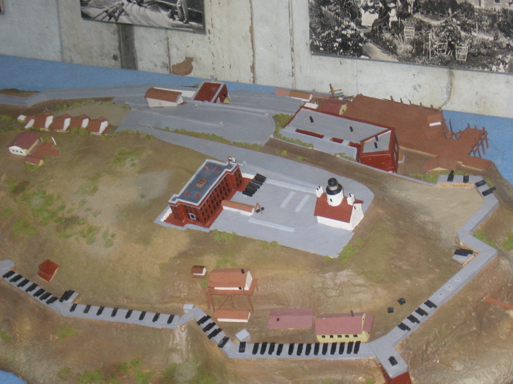
Model of Alcatraz, 1866-68 |
secure prison for notorious criminals. Even though they avoided
the island as they believed that evil spirits resided there due to the
bad atmosphere they got from the place, they were using it for deporting
their criminals under the tribal law to live on the island in isolation.
They also gathered eggs of birds and marine food from the island. Even
after the Spanish discovered the Island in 1759, and started spreading
Christianity, the natives who did not want to convert used the islands
as their refuge.
19th century
However, the earliest recorded owner of the island of
Alcatraz is Julian Workman, to whom it was given by Mexican governor Pio
Pico in June 1846, with the understanding that Workman would build a lighthouse
on it. Julian Workman is the baptismal name of William Workman, co-owner
of Rancho La Puente and personal friend of Pio Pico. Later in 1846, acting
in his capacity as Military Governor of California, John C. Fremont, champion
of Manifest Destiny and leader of the Bear Flag Republic, bought the island
for $5,000 in the name of the United States government from Francis Temple.
In 1850, President Millard Fillmore ordered that Alcatraz Island be set
aside specifically for military purposes based upon the U.S. acquisition
of California from Mexico following the Mexican-American War. Fremont had
expected a large compensation for his initiative in purchasing and securing
Alcatraz Island for the U.S. government, but the U.S. government later
invalidated the sale and paid Fremont nothing. Fremont and his heirs sued
for compensation during protracted but unsuccessful legal battles that
extended into the 1890s.
Following the acquisition of California by the United
States as a result of the Treaty of Guadalupe Hidalgo which ended the Mexican-American
War (1848), and the onset of the California Gold Rush the following year,
the U.S. Army began studying the suitability of Alcatraz Island for the
positioning of coastal batteries to protect the approaches to San Francisco
Bay. In 1853, under the direction of Zealous B. Tower, the United States
Army Corps of Engineers began fortifying the island, work which continued,
and the citadel was completed in 1859, on a budget of $87,689. The first
step in this direction, taken up in 1853, was the start of construction
of a fortress or citadel at the top of sandstone rock outcrops. The island
was encircled with steep walls built of stone and bricks abutting the rock
faces, and buildings for accommodating defense personnel and offices and
temporary launching jetty were also added. A lighthouse was built and 11
cannons were fixed. The main fortress took many years to build as the building
material (granite) required for construction had to be imported from China.
Army engineer James B. McPherson, later to become a prominent
general during the Civil War, was one of the earliest commanders to serve
on Alcatraz in 1858. The three-storied citadel took final shape by 1859
when gun positions, roads, guard houses and draw bridge over the moat (encircling
the citadel) were all added. The citadel had housing capacity for 200 soldiers
with food storage facility to last for four months in case of any long
drawn attack. In 1859, the coastal defense system became a reality and
Captain Joseph Stewart was commander of the island forces which included
86 men of Company H, Third U.S. Artillery, before departing from the island
in 1861 on the outbreak of the Civil War. The military officers wore blue
suits and white gloves. |
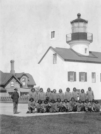
Hopi inmates of Alcatraz citadel. |
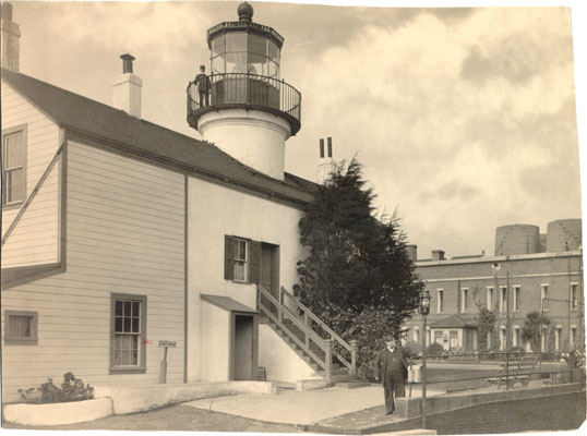
Lighthouse and citadel building, c. 1893 |
In 1861, the citadel commenced function as a prison,
with tiny new cells being added to the basement, and in 1867 was extended,
becoming a long-term military prison in 1868. The citadel on Alcatraz was
crucial to defense during the American Civil War (18611865), having some
111 cannons encircling the island at peak, and was also used as a war camp.
During the Civil War, the defense establishment at Alcatraz Citadel had
the onerous task to defuse the possibility of any local war between the
Union and Confederate supporters who were both part of the population of
California, and to protect San Francisco. Ammunition in the form of 10,000
muskets and 150,000 cartridges was supplied to the fort, which made the
Fort Alcatraz and the island most impregnable and thus leaving any plans
of the Confederate soldiers of taking control of the San Francisco Bay
and California State could be taken under its fold was thwarted. Alcatraz
was officially designated as a military prison on August 27, 1861. In March
1863, when there was a threat that the San Francisco Bay would be captured
by the Confederates, the schooner, which was to carry out the operation
set sail; the U.S. Navy prevented the schooner from moving out and captured
the crew along with ammunition and 15 confederates who were hiding in the
galleys of the ship. Consequent to this, the importance of Alcatraz increased,
more and more |
confederates and civilians were arrested for reasons of treason
and kept in the military prison, and to accommodate the increased number
of prisoners, a temporary makeshift wooden prison was built in 1863 to
the north of the guardhouse. In 1864, with civil war showing no signs of
abating, fortifications were provided in the fort in the form of 15-inch
Rodman cannons and more "bomb-proof barracks built. At the time of end
of the Civil War in 1865, there were more than one hundred cannons in the
island, which were never put to any aggressive battle, but used only once
to provide gun salute in honor of President Abraham Lincoln at his official
funeral procession held in San Francisco.
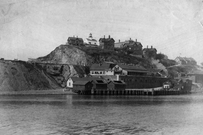
Alcatraz Island, 1895 |
As the civil war ended, the military prison housed Confederate
sympathizers who celebrated Lincoln's death. During the Indian Wars that
followed the civil war, Indians who went against the government were sent
to the Alcatraz prison. On June 5, 1873, Paiute Tom was the first Native
American who was imprisoned there on transfer from Camp McDermit in Nebraska.
In the 1870s, Major George Mendell ordered the prisoners, aided by mules,
to assist in changing the natural landscape of the island and creating
a top level, dumping debris into the coves and bay.In 1882, the citadel
was enlarged to provide more accommodation for the families of the military
officers working on Alcatraz. Between 1873 and 1895, 32 Native Americans
were imprisoned at the citadel on Alcatraz, including 19 Hopi men held
in captivity there between January and August 1895 after being transferred
from Fort Defiance. The island continued to develop in the 1880s and in
1898 the population of Alcatraz increased dramatically from 26 to over
450 due to the Spanish American War and placed a demand for new buildings.
The original barracks evolved into Building 64 in 1905. The first hospital
on Alcatraz opened in 1893.
As the number of prisoners to be housed in the citadel
increased, more space was built in the form of the Upper Prison, which
consisted of three wooden structures, each of two tiers, with the lower
prison getting converted as a workshop. However, both Upper and Lower Prison
cells, being made of wood, were frequently subject to fire hazards, and
this led to change of the structural form of the barracks; concrete structures
were built, replacing the wooden ones. |
20th century
In 1904, an upper prison building was built at a higher
level on the island and replaced the lower prison, with a capacity of 307
inmates.
Alcatraz was renamed as the "Pacific Branch, U.S. Military
Prison in 1907, and as the importance of the Island citadel became less
and less obvious due to modernization of the naval facilities, infantry
soldiers were shifted and prison guards brought in their place. It developed
a reputation for its brutal methods of torturing prisoners, placing prisoners
in pitch black cells for up two weeks.
Alcatraz was barely affected by the 1906 San Francisco
earthquake which devastated the city, and the prison population dramatically
increased as prisoners were temporarily transferred to the island due to
damage in the city. In 1907, Alcatraz Citadel ceased function as a military
defense and became the Pacific Branch, U.S. Military Prison solely. When
the original 1860s citadel collapsed in 1908, the Citadel was demolished
in 1909 up to its basement over which the new prison was built by the military
prisoners between 1909 and 1911 and named as the Pacific Branch, U.S.
Disciplinary Barracks for the U.S. Army, which became popular as "The
Rock". The prison was entirely rebuilt in concrete in 1910-1912 under the
command of Colonel Reuben Turner on a $250,000 budget on the site of the
remains and short-lived upper prison building. Many of the former underground
tunnels and chambers of the original fort remain today and are still accessible.
This building was modernized in 1934 when it reopened as a federal penitentiary,
the notorious Alcatraz prison which held America's most ruthless criminals
until 1963.
During the World War I, the citadel was used for incarcerating
military prisoners as also German Prisoners of War, which necessitated
building of a larger building structure by demolishing the old upper and
lower prisons. A new cell house formed of four cell blocks with 600 cells
was built, in 1912, which at that time was reported to be the largest reinforced
concrete building in the world; the cells had toilet and electricity facilities.
In the new established order, facilities for education
and rehabilitation of prisoners with minimum offence were also introduced
which resulted in many reformed prisoners getting back to the army. Even
though the prison was a military establishment, it had its fair share of
prison escapes. 29 escapes were reported involving 80 convicts out of which
62 were caught and tried while the rest of the prisoners were not traced.
In the prison escape of November 28, 1918, there were four prisoners who
escaped in rafts, and they were seen at Sutro Forest. However, only one
was caught and the others escaped.
Due to high costs of maintenance of the Alcatraz as a
defense establishment, a well thought out plan was mooted to convert it
into the Alcatraz Federal Penitentiary. Also during this period crime rate
had escalated in the country due to the great depression with prohibition
further exacerbating the situation resulting in mobsters and gangsters
operating freely indulging in looting, violence and killings, with the
law enforcing agencies failing to cope with the situation; prison escapes
had become the order of the day. The suggestion to convert the Military
Prison into a Federal Penitentiary was welcomed by the President Herbert
Hoover and thus the maximum-security prison was created. The proposal for
transfer of Alcatraz to the Bureau of Prisons was initiated in October
1933 and after a vigorous adaption from the military prison throughout
1934, it opened in August 1934, ending some eighty years of U.S. Army occupation.
With this change of guard, 32 hardcore prisoners remained at Alcatraz while
the rest were shifted to the prisons at Fort Leavenworth, Kansas, United
States Penitentiary, Atlanta, Fort Jay, New Jersey and several others.
Architecture and fittings
The main mode of transport accessing the island was the
General McPherson. Upon embarking at the port, the main grounds would be
reached by a "long dreary corridor" known as the sally port and a drawbridge
surrounded by a dry moat, 12 feet (3.7 m) below. It could hold up to 200
men during an emergency and enough supplies to last four months. Alcatraz
Citadel consisted of a basement, which contained the kitchen, bakery, bedrooms,
storerooms and jail cells, and two levels above ground which contained
the military personnel quarters, servant quarters, parlors and a mess room.
In-ground water tanks and water tanks were situated on the roof of the
citadel. Other buildings included the Batteries of Rosecranz and Halleck
in the north, the barracks building in the northeast, the Battery of McClellan
and Fog Bell House in the south, the Battery of McPherson in the west and
the Batteries of Stevens and Mansfield in the northwest and the lighthouse
aside the main citadel. Battery McClellan was equipped with a 15-inch Rodman
gun weighing over 25 tons, capable of launching a 330-pound explosive 4,680
yards when angled at 25 degrees. The Parade Grounds were located in the
left centre. When the new concrete prison was built in 1910-2, iron staircases
in the interior were retained from the old citadel and massive granite
blocks originally used as gun mounts were reused as the wharf's bulkheads
and retaining walls.
|
.
All articles submitted to the "Brimstone
Gazette" are the property of the author, used with their expressed permission.
The Brimstone Pistoleros are not
responsible for any accidents which may occur from use of loading
data, firearms information, or recommendations published on the Brimstone
Pistoleros web site. |
|