| Taos, New Mexico - Wikipedia
Taos /?ta?s/ is a town in Taos County in the north-central
region of New Mexico in the Sangre de Cristo Mountains, incorporated in
1934. As of the 2010 census, its population was 5,716. Other nearby communities
include Ranchos de Taos, Cañon, Taos Canyon, Ranchitos, El Prado,
and Arroyo Seco. The town is close to Taos Pueblo, the Native American
village and tribe from which it takes its name.
Taos is the county seat of Taos County. The English name
Taos derives from the native Taos language meaning "place of red willows".
Taos is the principal city of the Taos, NM Micropolitan
Statistical Area, which includes all of Taos County.
History
Taos Pueblo
The Taos Pueblo, which borders the town of Taos on its
north side, has been occupied for nearly a millennium. It is estimated
that the pueblo was built between 1000 and 1450 A.D., with some later expansion,
and the pueblo is considered to be the oldest continuously inhabited community
in America.
Located in a tributary valley off the Rio Grande, it is
the most northern of the New Mexico pueblos. The Pueblo, at some places
five stories high, is a combination of many individual homes with common
walls. There are over 1,900 people in the Taos pueblo community. Some of
them have modern homes near their fields and stay at their homes on the
pueblo during cooler weather. There are about 150 people who live at the
pueblo year-around. The Taos Pueblo was added as an UNESCO World Heritage
Site in 1992 as one of the most significant historical cultural landmarks
in the world; other sites include the Taj Mahal, Great Pyramids and the
Grand Canyon in the United States.
Spanish colonization
Taos was established c. 1615 as Don Fernando de Taos,
following the Spanish conquest of the Indian Pueblo villages by Geneva
Vigil. Initially, relations of the Spanish settlers with Taos Pueblo were
amicable, but resentment of meddling by missionaries, and demands by encomenderos
for tribute, led to a revolt in 1640; Taos Indians killed their priest
and a number of Spanish settlers, and fled the pueblo, not returning until
1661.
In 1680, Taos Pueblo joined the widespread Pueblo Revolt.
After the Spanish Reconquest of 1692, Taos Pueblo continued armed resistance
to the Spanish until 1696, when Governor Diego de Vargas defeated the Indians
at Taos Canyon.
During the 1770s, Taos was repeatedly raided by Comanches
who lived on the plains of what is now eastern Colorado. Juan Bautista
de Anza, governor of the Province of New Mexico, led a successful punitive
expedition in 1779 against the Comanches.
Taos settlement
Between 1780 and 1800, Don Fernando de Taos (now Taos),
was established. Between 1796 and 1797 the Don Fernando de Taos Land Grant
gave land to 63 Spanish families in the Taos valley. It was built as a
fortified plaza with adobe buildings and is now a central plaza surrounded
by residential areas. Mountain men who trapped for beaver nearby made Taos
their home in the early 1800s.
U.S. territory and statehood
Mexico ceded the region to the U.S. in the Treaty of Guadalupe
Hidalgo in 1848 after the MexicanAmerican War. After the U.S. takeover
of New Mexico in 1847, Hispanics and American Indians in Taos staged a
rebellion, known as the Taos Revolt, in which the newly appointed U.S.
Governor, Charles Bent, was killed. New Mexico was a territory of the United
States beginning 1850 and became a state in 1912.
For historical reasons, the American flag is displayed
continuously at Taos Plaza (both day and night). This derives from the
time of the American Civil War, when Confederate sympathizers in the area
attempted to remove the flag. The Union officer Kit Carson sought to discourage
this activity by having guards surround the area and fly the flag 24 hours
a day.
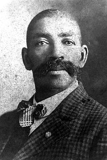
"The Padre of Isleta", Anton Docher first served as a
priest in Taos before leaving for Isleta in 1891.
Taos art colony
Beginning in 1899, artists began to settle in Taos; six
formed the Taos Society of Artists in 1915. In time, the Taos art colony
developed. Many paintings were made of local scenes, especially of Taos
Pueblo and activities there, as the artists often modelled Native Americans
from the pueblo in their paintings. Some of the artists' studios have been
preserved and may be viewed by visitors to Taos. These include the Ernest
L. Blumenschein House, the Eanger Irving Couse House and StudioJoseph
Henry Sharp Studios, and the Nicolai Fechin house, all of which are listed
on the National Register of Historic Places. Influential later 20th-century
Taos artists include R. C. Gorman and Agnes Martin.
Historical places and tourism
Taos is home to more than twenty sites on the National
Register of Historic Places.
Pueblos
Three miles north of Taos is Taos
Pueblo; Picuris Pueblo is about 25 miles south.
Taos art colony
Many of the historic sites are homes
and studios of artists, including the Mabel Dodge Luhan House, Eanger Irving
Couse House and StudioJoseph Henry Sharp Studios, the Nicolai Fechin House,
the Leon Gaspard House, and the Ernest Martin Hennings House. On Ledoux
street, just south of the Taos Plaza, is the Ernest L. Blumenschein House
and Harwood House.
Other historic sites
The center of the Taos Downtown Historic
District is the Taos Plaza. Just west of that is the Our Lady of Guadalupe
Church. North of the Taos Plaza is the Governor Charles Bent House and
the Taos Inn. Further north in Taos The Bernard Beimer House. On the southwestern
edge of the Taos Historic district is La Loma Plaza Historic District.
East of the plaza on Kit Carson Road is the Kit Carson House.
North of Taos is the Turley Mill and Distillery
Site and the Rio Grande Gorge Bridge. Just outside of Taos in Ranchitos
is the Martinez Hacienda, the home turned museum of the late Padre Antonio
José Martínez. South of Taos is the Ranchos de Taos Plaza
with the San Francisco de Asis Mission Church.
Other historic places
Twenty miles northwest is the D. H. Lawrence Ranch (originally
known as the Kiowa Ranch and now owned by the University of New Mexico),
the home of the English novelist in the 1920s. It is believed that his
ashes are buried there at the D. H. Lawrence Memorial. Another novelist
who lived for a while in Taos was Alexander Trocchi.
Tourism
Art
There are many ways to explore art
in Taos. There are three Art Museums in Taos: Harwood Museum of Art, Taos
Art Museum and Millicent Rogers Museum that provide art from the pueblo
Native Americans, Taos Society of Artists and modern and contemporary artists
of the Taos art colony. The town has more than eighty art galleries and
there are several houses of the Taos Society of Artists.
Performing arts
There are several local venues for
the performing arts in Taos. The Taos Center for the Arts (TCA) draws nationally
renowned and local performers at the Taos Community Auditorium. They also
present independent film series. Three chamber music groups perform at
TCA: Taos School of Music, Taos Chamber Music Group, and Music from Angel
Fire. The Harwood Museum of Art is site of other performances and lectures.
The Town of Taos Convention Center offers a venue for other local performances.
Recreation
Summer activities
The Taos valley, Rio Grande and Taos
mountains provide many opportunities for recreation, such as fly fishing,
horseback riding, golfing, hot air ballooning, llama trekking, rafting,
mountain biking and more. Nearby, the Cumbres & Toltec Scenic Railroad
provides a ride through the Toltec Gorge and Rocky Mountain passes in an
authentic narrow-gauge steam railroad.
Winter activities
In the winter many people come to
Taos to ski. Wheeler Peak, at 13,161 feet, is the highest peak in New Mexico.
The Taos area has four ski areas Taos Ski Valley, Red River ski area,
Sipapu (ski area) and Angel Fire ski area. Other winter activities include
hot air ballooning, horseback riding, snow-shoeing, cross-country skiing,
ice skating, ice fishing and snowmobiling.
Demographics
As of the 2010 census Taos had a population of 5,716.
The median age was 44. The ethnic and racial composition of the population
was 40.1% non-Hispanic white, 0.7% African American, 1.0% Asian, 5.3% Native
American, 0.3% non-Hispanics reporting some other race, 5.4% reporting
two or more races and 51.9% Hispanic or Latino of any race.
As of the census[18] of 2000, there were 4,700 people,
2,067 households, and 1,157 families residing in the town. The population
density was 874.5 inhabitants per square mile (337.6/km2). There were 2,466
housing units at an average density of 458.8 per square mile (177.1/km2).
The racial makeup of the town was 68.04% White, 0.53% African American,
4.11% Native American, 0.62% Asian, 0.11% Pacific Islander, 21.66% from
other races, and 4.94% from two or more races. Hispanic or Latino of any
race were 54.34% of the population.
There were 2,067 households out of which 27.5% had children
under the age of 18 living with them, 34.7% were married couples living
together, 16.2% had a female householder with no husband present, and 44.0%
were non-families. 37.3% of all households were made up of individuals
and 12.1% had someone living alone who was 65 years of age or older. The
average household size was 2.18 and the average family size was 2.87.
In the town the population was spread out with 23.0% under
the age of 18, 6.6% from 18 to 24, 26.4% from 25 to 44, 27.8% from 45 to
64, and 16.2% who were 65 years of age or older. The median age was 41
years. For every 100 females there were 85.0 males. For every 100 females
age 18 and over, there were 81.3 males.
The median income for a household in the town was $25,016,
and the median income for a family was $33,564. Males had a median income
of $27,683 versus $23,326 for females. The per capita income for the town
was $15,983. About 17.9% of families and 23.1% of the population were below
the poverty line, including 26.8% of those under age 18 and 24.4% of those
age 65 or over.
Geography and climate
Taos is located at 36°23?38?N 105°34?36?W (36.393979,
?105.576705).
The town has a total area of 5.4 square miles (14 km2),
all land.
Taos is located near the Rio Pueblo de Taos, a tributary
of the Rio Grande. Just to the west of Taos is the Rio Grande Gorge, cutting
through the basalt flows of the Taos Plateau volcanic field and crossed
by the Rio Grande Gorge Bridge, now a part of U.S. Route 64.
The elevation of the town is 6,967 feet (2,124 m). Just
north of Taos is Wheeler Peak, at 13,161 feet (4,011 m), the highest point
in New Mexico. Taos has a semi-arid climate (Köppen BSk) with extreme
diurnal variations of temperature and low rainfall. Even when summer days
get extremely hot, nights can be pleasantly cool.
Education
Elementary, middle and high schools
The town's public schools operated
by Taos Municipal Schools include Arroyos del Norte Elementary School,
Enos García Elementary (also Taos Elementary School), Ranchos Elementary
School, Taos Middle School, Taos High School and Taos Cyber Magnet School.
Charter schools include Anansi Charter
School, Taos Academy (State Charter), Taos Municipal Charter School and
Vista Grande High School. Also in the area are additional alternative and
private schools: Chrysalis Alternative School, Sped Discipline, Yaxche
Private School, Taos Christian Academy, and San Francisco De Asis School.
Universities
Dallas-based Southern Methodist University
operates a 295 acres (1.19 km2) campus at Fort Burgwin in Taos.
Albuquerque-based University of New
Mexico (UNM) operates a community campus in Taos, with eight affiliated
buildings in Taos, such as the UNM Harwood Museum of Art and Taos High
School where some classes are held.
Government
The town of Taos is incorporated under the mayor-council
form of government. The town was incorporated on May 7, 1934. The town
seal is a logo of the town of Taos with the year of incorporation "1934"
in the center, and on the outer edge, the words "Town of Taos, New Mexico".
The elective officers of the town include: the mayor,
4 members of the governing body forming the town council, and a municipal
judge. The town council is the board of finance of the town. The town manager
and finance director serve as the nonvoting members to the board of finance.
Key positiongs within the town government are town manager, appointed by
the major, Town Attorney, Town Clerk, Town Engineer and Chief of Police.
Taos is predominantly made up of Democrats; In 2008, approximately
74% of registered Taos County voters were Democrats, 13% Republicans and
about 13% were alternate parties or decline to affiliate with a party.
Transportation
Public transportation
Chile Line, Taos public transportation
The Chile Line, operated by the town
of Taos, is Taos' only public transportation system. The transit system
provides paratransit service for citizens with special needs and ensures
that all route buses are American Disability Act (ADA) equipped.
Taos Express
The Taos Express is a shuttle service
created by the Town of Taos to promote local tourism. It provides transportation
on Fridays, Saturdays and Sundays from the Taos Plaza to the New Mexico
Rail Runner, Santa Fe Municipal Airport, and Santa Fe transit.
Regional public transportation
The North Central Regional Transit
District (NCRTD) has public transportation service between regional areas.
The Taos region has service to Cerro, Penasco, Questa, Red River, the Rio
Grande corridor and the University of New Mexico Taos Klaur campus. At
the OhKay Owingeh Casino passengers can connect to other regional routes,
such as Espanola, Santa Fe, Los Alamos, and Northern Pueblos area. In 2003
the Regional Transit District Act was enacted, which authorized the creation
of Regional Transit Districts (RTD's) in the state of New Mexico; In September,
2004, the North Central Regional RTD was the first RTD to be certified
by the New Mexico Transportation Commission.
Airports
Taos Regional Airport (SKX) is under the direct supervision
of the Town of Taos. The airport is located just a few miles north of the
Town of Taos on U.S. Route 64 towards the Rio Grande Gorge Bridge.
Other airports in New Mexico include the Santa Fe Municipal
Airport and Albuquerque International Sunport.
|
Santa Fe, New Mexico - Wikipedia
| Santa Fe (/?sænt??fe?/; (Tewa: Ogha Po'oge, Navajo:
Yootó)) is the capital of the state of New Mexico. It is the fourth-largest
city in the state and is the seat of Santa Fe County. Santa Fe is the oldest
capital city in the United States and the oldest city in New Mexico. Santa
Fe (meaning "holy faith" in Spanish) had a population of 69,204 in 2012.
It is the principal city of a Metropolitan Statistical Area which encompasses
all of Santa Fe County and is part of the larger Albuquerque-Santa Fe-Las
Vegas Combined Statistical Area. The citys full name when founded was
La Villa Real de la Santa Fe de San Francisco de Asís ("The Royal
Town of the Holy Faith of St. Francis of Assisi").
History
Spain and Mexico
Santa Fe settlers are churlish types
who are accustomed to live apart from each other, as neither fathers nor
sons associate with each other."
Governor Fermín de Mendinueta,
c. 1776.
The city of Santa Fe was originally occupied by a number
of Pueblo Indian villages with founding dates between 1050 to 1150. One
of the earliest known settlements in what today is downtown Santa Fe came
sometime after 900. A Native American group built a cluster of homes that
centered around the site of todays Plaza and spread for half a mile to
the south and west; the village was called Ogapoge. The Santa Fe River
provided water to people living there. The Santa Fe River is a seasonal
waterway which was a year round stream until the 1700s. As of 2007, the
river was recognized as the most endangered river in the United States,
according to the conservation group American Rivers.
|
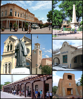
Downtown Santa Fe |
Don Juan de Oñate led the first effort to colonize
the region in 1598, establishing Santa Fe de Nuevo México as a province
of New Spain. Under Juan de Oñate and his son, the capital of the
province was the settlement of San Juan de los Caballeros north of Santa
Fe near modern Ohkay Owingeh Pueblo. New Mexico's second Spanish governor,
Don Pedro de Peralta, however, founded a new city at the foot of the Sangre
de Cristo Mountains in 1607, which he called La Villa Real de la Santa
Fe de San Francisco de Asís, the Royal Town of the Holy Faith of
Saint Francis of Assisi. In 1610, he made it the capital of the province,
which it has almost constantly remained, making it the oldest state capital
in the United States.
Except for the years 16801692, when, as a result of the
Pueblo Revolt, the native Pueblo people drove the Spaniards out of the
area known as New Mexico, later to be reconquered by Don Diego de Vargas,
Santa Fe remained Spain's provincial seat until the outbreak of the Mexican
War of Independence in 1810. In 1824 the city's status as the capital of
the Mexican territory of Santa Fe de Nuevo México was formalized
in the 1824 Constitution.
United States
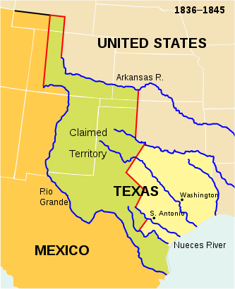
The Republic of Texas map showing lands
claimed by Texas after 1836 and present-day
outlines of states superimposed on the
boundaries of 18361845. |
The Republic of Texas had claimed Santa Fe as part of
the western portion of Texas along the Rio Grande when it seceded from
Mexico in 1836. In 1841, a small military and trading expedition set out
from Austin, Texas, with the aim of gaining control over the Santa Fe Trail.
Known as the Texan Santa Fe Expedition, the force was poorly prepared and
was easily captured by the Mexican army. In 1846, the United States declared
war on Mexico, and Brigadier General Stephen W. Kearny led the main body
of his Army of the West of some 1,700 soldiers into the city to claim it
and the whole New Mexico Territory for the United States. By 1848 the U.S.
officially gained New Mexico through the Treaty of Guadalupe Hidalgo.
Colonel Alexander William Doniphan, under the command
of Kearny, recovered ammunition from Santa Fe labeled "Spain 1776", showing
both the quality of communication and military support New Mexico received
under Mexican rule.
American visitors saw little promise in the remote town.
One traveller in 1849 wrote:
"I can hardly imagine how Santa Fe
is supported. The country around it is barren. At the North stands a snow-capped
mountain while the valley in which the town is situated is drab and sandy.
The streets are narrow... A Mexican will walk about town all day to sell
a bundle of grass worth about a dime. They are the poorest looking people
I ever saw. They subsist principally on mutton, onions and red pepper."
letter from an American traveler,
1849.
In 1851, Jean Baptiste Lamy arrived; in 1853 he became
bishop of New Mexico, Arizona, Utah, and Colorado and traveled to France,
Rome, Tucson, Los Angeles, St. Louis, New Orleans and Mexico City. He built
Saint Francis Cathedral and shaped Catholicism in the region until his
death in 1888.
|
For a few days in March 1862, the Confederate flag of General
Henry Sibley flew over Santa Fe, until he was forced to withdraw by Union
troops, who destroyed his logistical trains following the battle of Glorietta
Pass.
On October 21, 1887, "The Padre of Isleta", Anton Docher
went to New Mexico where he was ordained as a priest in the St Francis
Cathedral of Santa Fe by Bishop Jean-Baptiste Salpointe. After a few years
spent in Santa Fe, Bernalillo and in Taos, he arrived in Isleta on December
28, 1891. He wrote an interesting ethnological article published in The
Santa Fé Magazine on June,1913, in which he describes the early
20th century's life in the Pueblos.
Santa Fe was originally envisioned as an important stop
on the Atchison, Topeka and Santa Fe Railway. But as the tracks progressed
into New Mexico, the civil engineers decided that it was more practical
to go through Lamy, a town in Santa Fe County to the south of Santa Fe.
A branch line was completed from Lamy to Santa Fe in 1880 and the Denver
and Rio Grande Western Railroad extended the narrow gauge Chili Line from
the nearby city of Española to Santa Fe in 1886, but the result
of bypassing Santa Fe was a gradual economic decline. This was reversed
in part through the creation of a number of resources for the arts and
archaeology, notably the School of American Research, created in 1907 under
the leadership of the prominent archaeologist Edgar Lee Hewett. The first
airplane to fly over Santa Fe was piloted by Rose Dugan, carrying Vera
von Blumenthal as passenger. Together they started the development of the
Pueblo Indian pottery industry, a major contribution to the founding of
the annual Santa Fe Indian Market.
In 1912, New Mexico became the United States of America's
47th state, with Santa Fe as its capital.
20th century
1912 Plan
In 1912, when the town had only 5,000 people, the city's
civic leaders designed and enacted a sophisticated city plan that incorporated
elements of the City Beautiful movement, the city planning movement, and
the German historic preservation movement. It anticipated limited future
growth, considered the scarcity of water, and recognized the future prospects
of suburban development on the outskirts. The planners foresaw conflicts
between preservationists and scientific planners. They set forth the principle
that historic streets and structures be preserved and that new development
must be harmonious with the city's character.
Artists and tourists
The mainline of the railroad bypassed Santa Fe, and it
lost population. However artists and writers, as well as retirees, were
attracted to the cultural richness of the area, the beauty of the landscapes
and its dry climate. Local leaders began promoting the city as a tourist
attraction. The city sponsored architectural restoration projects and erected
new buildings according to traditional techniques and styles, thus creating
the "Santa Fe style". Edgar L. Hewett, founder and first director of the
School of American Research and the Museum of New Mexico in Santa Fe, was
a leading promoter. He began the Santa Fe Fiesta in 1919 and the Southwest
Indian Fair in 1922 (now known as the Indian Market). When he tried to
attract a summer program for Texas women, many artists rebelled saying
the city should not promote artificial tourism at the expense of its artistic
culture. The writers and artists formed the Old Santa Fe Association and
defeated the plan.
Japanese American internment camp
During World War II, Santa Fe was the location of a Japanese
American internment camp. Beginning in June 1942, the Department of Justice
held 826 Japanese American men arrested after Pearl Harbor in a former
Civilian Conservation Corps site that had been acquired and expanded for
the purpose. Although there was a lack of evidence and no due process,
the men were held on suspicion of fifth column activity. Security at Santa
Fe was similar to a military prison, with twelve-foot barbed wire fences,
guard towers equipped with searchlights, and guards carrying rifles, side
arms and tear gas. By September, the internees had been transferred to
other facilities523 to War Relocation Authority concentration camps, 302
to Army internment campsand the site was used to hold German and Italian
nationals. In February 1943, these civilian detainees were transferred
to D.O.J. custody and the camp was expanded to take in 2,100 men segregated
from the general population of Japanese American inmates, mostly Nisei
and Kibei who had renounced their U.S. citizenship and other "troublemakers"
from the Tule Lake Segregation Center. In 1945, four internees were seriously
injured when violence broke out between the internees and guards in an
event known as the Santa Fe Riot. The camp remained open past the end of
the war; the last detainees were released in mid 1946, and the facility
was closed and sold as surplus soon after. The camp was located in what
is now the Casa Solana neighborhood.
Geography
According to the United States Census Bureau, the city
has a total area of 37.4 sq mi (96.9 km2), of which 37.3 sq mi (96.7 km2)
is land and 0.077 sq mi (0.2 km2) (0.21%) is water.
Santa Fe is located at 7,199 feet (2134 m) above sea level,
making it the highest state capital in the United States.
Climate
Santa Fe experiences a semi-arid climate (Köppen
BSk), with chilly winters, and very warm summers. The 24-hour average temperature
in the city ranges from 30.3 °F (?0.9 °C) in December to 70.1 °F
(21.2 °C) in July. Due to the relative aridity and elevation, average
diurnal temperature variation exceeds 25 °F (14 °C) in every month,
and 30 °F (17 °C) much of the year. The city usually receives 6
to 8 snowfalls a year between November and April. Heaviest rainfall occurs
in July and August, with the arrival of the North American Monsoon.
Santa Fe style and "The City Different"
"This year we are making a studied conscious
effort not to be studied or conscious. Santa Fe is now one of the most
interesting art centers in the world and you, O Dude of the East, are privileged
to behold the most sophisticated group in the country gamboling freely.
... And Santa Fe, making you welcome, will enjoy itself hugely watching
the Dude as he gazes. Be sure as you stroll along looking for the quaint
and picturesque that you are supplying your share of those very qualities
to Santa Fe, the City Incongruous. ... Be yourself, even if it includes
synthetic cowboy clothes, motor goggles and a camera." 1928 Santa Fe Fiesta
Program
The Spanish laid out the city according to the "Laws of
the Indies", town planning rules and ordinances which had been established
in 1573 by King Philip II. The fundamental principle was that the town
be laid out around a central plaza. On its north side was the Palace of
the Governors, while on the east was the church that later became the Cathedral
Basilica of Saint Francis of Assisi.
An important style implemented in planning the city was
the radiating grid of streets centering from the central Plaza. Many were
narrow and included small alley-ways, but each gradually merged into the
more casual byways of the agricultural perimeter areas. As the city grew
throughout the 19th century, the building styles evolved too, so that by
statehood in 1912, the eclectic nature of the buildings caused it to look
like "Anywhere USA". The city government realized that the economic decline,
which had started more than twenty years before with the railway moving
west and the federal government closing down Fort Marcy, might be reversed
by the promotion of tourism.
To achieve that goal, the city created the idea of imposing
a unified building style the Spanish Pueblo Revival look, which was based
on work done restoring the Palace of the Governors. The sources for this
style came from the many defining features of local architecture: vigas
(rough, exposed beams that extrude through supporting walls, and are thus
visible outside as well as inside the building) and canales (rain spouts
cut into short parapet walls around flat roofs), features borrowed from
many old adobe homes and churches built many years before and found in
the Pueblos, along with the earth-toned look (reproduced in stucco) of
the old adobe exteriors.
After 1912 this style became official: all buildings were
to be built using these elements. By 1930 there was a broadening to include
the "Territorial", a style of the pre-statehood period which included the
addition of portales (large, covered porches) and white-painted window
and door pediments (and also sometimes terra cotta tiles on sloped roofs,
but with flat roofs still dominating). The city had become "different".
However, "in the rush to pueblofy" Santa Fe, the city lost a great deal
of its architectural history and eclecticism. Among the architects most
closely associated with this new style are T. Charles Gaastra and John
Gaw Meem.
By an ordinance passed in 1957, new and rebuilt buildings,
especially those in designated historic districts, must exhibit a Spanish
Territorial or Pueblo style of architecture, with flat roofs and other
features suggestive of the area's traditional adobe construction. However,
many contemporary houses in the city are built from lumber, concrete blocks,
and other common building materials, but with stucco surfaces (sometimes
referred to as "faux-dobe", pronounced as one word: "foe-dough-bee") reflecting
the historic style.
In a September 2003 report by Angelou Economics, it was
determined that Santa Fe should focus their economic development efforts
in the following seven industries: Arts and Culture, Design, Hospitality,
Conservation Technologies, Software Development, Publishing and New Media,
and Outdoor Gear and Apparel. Three secondary targeted industries for Santa
Fe to focus development in are health care, retiree services, and food
& beverage. Angelou Economics recognized three economic signs that
Santa Fes economy was at risk of long term deterioration. These signs
were; a lack of business diversity which tied the city too closely to fluctuations
in tourism and the government sector; the beginnings of urban sprawl, as
a result of Santa Fe County growing faster than the city, meaning people
will move farther outside the city to find land and lower costs for housing;
and an aging population coupled with a rapidly shrinking population of
individuals under 45 years old, making Santa Fe less attractive to business
recruits.
The seven industries recommended by the report "represent
a good mix for short-, mid-, and long-term economic cultivation."
In 2005/2006, a consultant group from Portland, Oregon,
prepared a "Santa Fe Downtown Vision Plan" to examine the long-range needs
for the "downtown" area, roughly bounded by the Paseo de Peralta on the
north, south and east sides and by Guadalupe Street on the west. In consultation
with members of community groups, who were encouraged to provide feedback,
the consultants made a wide range of recommendations in the plan now published
for public and city review.
Government
The city of Santa Fe is a charter city. It is governed
by a mayor-council system. The city is divided into four electoral districts,
each represented by two councilors. Councilors are elected to staggered
four-year terms and one councilor from each district is elected every two
years.:Article VI
The municipal judgeship is an elected position and a requirement
of the holder is that they be a member of the state bar. The judge is elected
to four-year terms.:Article VII
The mayor is the chief executive officer of the city and
is a member of the governing body. The mayor has numerous powers and duties,
but does not vote with the councilors except to break ties.:Article V Day-to-day
operations of the municipality are undertaken by the city manager's office.:Article
VIII
Federal representation
The Joseph M. Montoya Federal Building and Post Office
serves as an office for U.S. federal government operations. It also contains
the primary United States Postal Service post office in the city. Other
post offices in the Santa Fe city limits include Coronado, De Vargas Mall,
and Santa Fe Place Mall. The U.S. Courthouse building, constructed in 1889,
was added to the National Register of Historic Places in 1973.
Arts and culture
The city is well known as a center for arts that reflect
the multicultural character of the city; it has been designated as a UNESCO
Creative City in Design, Crafts and Folk Art. Each Wednesday the alternative
weekly newspaper, The Santa Fe Reporter, publishes information on the arts
and culture of Santa Fe; and each Friday, the daily Santa Fe New Mexican
publishes Pasatiempo, its long-running calendar and commentary on arts
and events.
In 2012, the city was listed among the 10 best places
to retire in the U.S. by CBS Money Watch and U.S. News.
Visual art and galleries
The city and the surrounding areas have a high concentration
of artists. They have come over the decades to capture the natural beauty
of the landscape, the flora and the fauna. One of the most well-known New
Mexicobased artists was Georgia O'Keeffe, who lived for a time in Santa
Fe, but primarily in Abiquiu, a small village about 50 mi (80 km) away.
The New Mexico Museum of Art and Georgia O'Keeffe Museum own several of
her works. O'Keeffe's friend, western nature photographer Eliot Porter,
died in Santa Fe.
Canyon Road, east of the Plaza, has the highest concentration
of art galleries in the city, and is a major destination for international
collectors, tourists and locals. The Canyon Road galleries showcase a wide
array of contemporary, Southwestern, indigenous American, and experimental
art, in addition to Russian, Taos Masters, and Native American pieces.
Sculpture
There are many outdoor sculptures, including many statues
of Francis of Assisi, and several other holy figures, such as Kateri Tekakwitha.
The styles run the whole spectrum from Baroque to Post-modern. Notable
sculptors connected with Santa Fe include John Connell, Luis Jiménez,
Rebecca Tobey and Allan Houser.
Literature
Numerous authors followed the influx of specialists in
the visual arts. Well-known writers like D.H. Lawrence, Cormac McCarthy,
Kate Braverman, Douglas Adams, Roger Zelazny, Alice Corbin Henderson, Mary
Austin, Witter Bynner, Dan Flores, Paul Horgan, Rudolfo Anaya, George R.
R. Martin, Mitch Cullin, Evan S. Connell, Richard Bradford, John Masters,
Jack Schaefer, Michael Tobias, Hampton Sides and Michael McGarrity are
or were residents of Santa Fe. Walker Percy lived on a dude ranch outside
of Santa Fe before returning to Louisiana to begin his literary career.
Music, dance, and opera
Performance Santa Fe, formerly the Santa Fe Concert Association,
is the oldest presenting organization in Santa Fe. Founded in 1937, Performance
Santa Fe brings celebrated and legendary musicians as well as some of the
worlds greatest dancers and actors to the city from August through May.
The Santa Fe Opera's productions take place between late June and late
August each year. The city also hosts the Santa Fe Chamber Music Festival
which is held at about the same time, mostly in the St. Francis Auditorium
and in the Lensic Theater. Also in July and August, the Santa Fe Desert
Chorale holds its summer festival. Santa Fe has its own professional ballet
company, Aspen Santa Fe Ballet, which performs in both cities and tours
nationally and internationally. Santa Fe is also home to internationally
acclaimed Flamenco dancer's Maria Benitez Institute for Spanish Arts which
offers programs and performance in Flamenco, Spanish Guitar and similar
arts year round. Other notable local figures include the National Dance
Institute of New Mexico and German New Age musician Deuter.
Museums
Santa Fe has many museums located near the downtown
Plaza:
New Mexico Museum of Art collections
of Southwestern Arts.
Institute of American Indian Arts
Museum Native American arts with political aspects.
Georgia O'Keeffe Museum devoted
to the work of O'Keeffe and others whom she influenced.
New Mexico History Museum located
behind the Palace of the Governors.
Pablita Velarde Museum of Indian Women
in the Arts - a museum dedicated to Native Women artists.
Site Santa Fe A contemporary art
space.
Santa Fe Children's Museum - a children's
museum
Several other museums are located in the area known
as Museum Hill:
Museum of International Folk Art
folk arts from around the world.
Museum of Indian Arts and Culture
exhibits Native American arts.
Wheelwright Museum of the American
Indian Native American art and history.
Museum of Spanish Colonial Art Tradition
arts from the Spanish-colonial era to contemporary times.
Sports
The New Mexico Style were an American Basketball Association
franchise founded in 2005, but reformed in Texas for the 20078 season
as the El Paso S'ol (which folded without playing an ABA game in their
new city). The Santa Fe Roadrunners were a North American Hockey League
team, but moved to Kansas to become the Topeka Roadrunners. Santa Fe's
rodeo, the Rodeo De Santa Fe, is held annually the last week of June. In
May 2012 Santa Fe became the home of the Santa Fe Fuego of the Pecos League
of Professional Baseball Clubs. They play their home games at Fort Marcy
Park. Horse Racing events were held at The Downs at Santa Fe from 1971
until 1997.
Economy
Science and technology
Santa Fe has had an association with science and technology
since 1943 when the town served as the gateway to Los Alamos National Laboratory
(LANL), a 45-minute drive from the city. In 1984, the Santa Fe Institute
(SFI) was founded to research complex systems in the physical, biological,
economic, and political sciences. It hosts such Nobel laureates as Murray
Gell-Mann (physics), Philip Warren Anderson (physics), and Kenneth Arrow
(economics). The National Center for Genome Resources (NCGR) was founded
in 1994 to focus on research at the intersection among bioscience, computing,
and mathematics. In the 1990s and 2000s several technology companies formed
to commercialize technologies from LANL, SFI, and NCGR. This community
of companies has been dubbed the "Info Mesa."
Due to the presence of Los Alamos National Laboratory],
Sandia National Laboratories and the Santa Fe Institute, and because of
its attractiveness for visitors and an established tourist industry, Santa
Fe routinely serves as a host to a variety of scientific meetings, summer
schools, and public lectures, such as International q-bio Conference on
Cellular Information Processing, Santa Fe Institute's Complex Systems Summer
School, LANL's Center For Nonlinear Studies Annual Conference, and others.
Tourism
Touch the country [of New Mexico] and
you will never be the same again.
D.H. Lawrence, c. 1917.
After State government, tourism is a major element of
the Santa Fe economy, with visitors attracted year-round by the climate
and related outdoor activities (such as skiing in years of adequate snowfall;
hiking in other seasons) plus cultural activities of the city and the region.
Tourism information is provided by the convention and visitor bureau and
the chamber of commerce.
Most tourist activity takes place in the historic downtown,
especially on and around the Plaza, a one-block square adjacent to the
Palace of the Governors, the original seat of New Mexico's territorial
government since the time of Spanish colonization. Other areas include
Museum Hill, the site of the major art museums of the city as well as
the Santa Fe International Folk Art Market, which takes place each year
during the second full weekend of July. The Canyon Road arts area with
its galleries is also a major attraction for locals and visitors alike.
Some visitors find Santa Fe particularly attractive around
the second week of September when the aspens in the Sangre de Cristo Mountains
turn yellow and the skies are clear and blue. This is also the time of
the annual Fiestas de Santa Fe, celebrating the "reconquering" of Santa
Fe by Don Diego de Vargas, a highlight of which is the burning Zozobra
("Old Man Gloom"), a 50-foot (15 m) marionette.
Popular day-trips in the Santa Fe area include locations
such as the town of Taos about 70 mi (113 km) north of Santa Fe. The
historic Bandelier National Monument and the Valles Caldera can be found
about 30 mi (48 km) away. In addition, Santa Fe's ski area, Ski Santa Fe,
is about 16 mi (26 km) north of the city.
Transportation
Air
Santa Fe is served by the Santa Fe Municipal Airport.
Currently, American Eagle provides regional jet service to and from Dallas-Fort
Worth International Airport, which began on June 11, 2009. An additional
flight to and from Dallas-Fort Worth International Airport was added on
November 19, 2009 alongside a new flight to and from Los Angeles International
Airport. Since December 2012, Great Lakes Airlines has offered twice daily
flight service between Santa Fe, NM and Denver, CO. Many people fly into
the Albuquerque International Sunport and connect by other means to Santa
Fe.
Road
Santa Fe is located on I-25. In addition, U.S. Route 84
and U.S. Route 285 pass through the city along St. Francis Drive. NM-599
forms a limited-access road bypass around the northwestern part of the
city.
In its earliest alignment (19261937) U.S. Route 66 ran
through Santa Fe.
Public transportation
Santa Fe Trails operates a number of bus routes within
the city and also provides connections to regional transit.
The New Mexico Rail Runner Express is a commuter rail
service operating in Valencia, Bernalillo (including Albuquerque), Sandoval,
and Santa Fe Counties. In Santa Fe County, the service uses 18 miles (29
km) of new right-of-way connecting the BNSF Railway's old transcontinental
mainline to existing right-of-way in Santa Fe used by the Santa Fe Southern
Railway. Santa Fe is currently served by three stations, Santa Fe Depot,
South Capitol, and Santa Fe County/NM 599. A fourth station, Zia Road,
is under construction and does not yet have a planned opening date.
New Mexico Park and Ride, a division of the New Mexico
Department of Transportation, and the North Central Regional Transit District
operate primarily weekday commuter coach/bus service to Santa Fe from Torrance,
Rio Arriba, Taos, San Miguel and Los Alamos Counties in addition to shuttle
services within Santa Fe connecting major government activity centers.
Prior to the Rail Runner's extension to Santa Fe, New Mexico Park and Ride
operated commuter coach service between Albuquerque and Santa Fe.
Rail
Along with the New Mexico Rail Runner Express, a commuter
rail line serving the metropolitan areas of Albuquerque and Santa Fe, the
city or its environs are served by two other railroads. The Santa Fe Southern
Railway, now mostly a tourist rail experience but also carrying freight,
operates excursion services out of Santa Fe as far as Lamy, 15 miles (24
km) to the southeast. The Santa Fe Southern line is one of the United States'
few rails with trails. Lamy is also served by Amtrak's daily Southwest
Chief for train service to Chicago, Los Angeles, and intermediate points.
Passengers transiting Lamy may use a special connecting coach/van service
to reach Santa Fe.
Trails
Multi-use bicycle, pedestrian, and equestrian trails are
increasingly popular in Santa Fe, for both recreation and commuting. These
include the Dale Ball Trails, a 30-mile (48 km) network starting within
two miles (3.2 km) of the Santa Fe Plaza; the long Santa Fe Rail Trail
to Lamy; and the Santa Fe River Trail, which is in development. Santa Fe
is the terminus of three National Historic Trails: El Camino Real de Tierra
Adentro National Historic Trail, the Old Spanish National Historic Trail,
and the Santa Fe National Historic Trail.
|