| Indian Territory 1834 - 1907- from Wikipedia
As generic terms, Indian Territory, The Indian Territories,
or Indian Country describe an evolving land area set aside by the United
States Government for the relocation of the indigenous peoples of the Americas
who held aboriginal title to their land. In general, the tribes ceded land
they occupied in exchange for land grants in an area purchased by the United
States federal government from Napoleon, the Louisiana Purchase. The concept
of an Indian Territory was an outcome of the 18th- and 19th-century policy
of Indian removal. After the United States Civil War the policy of the
government was one of assimilation.
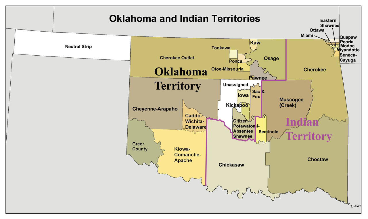
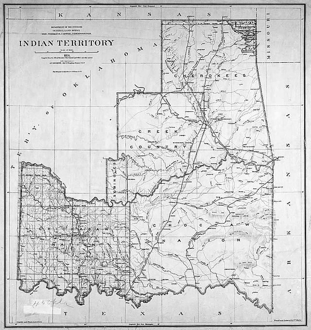
Oklahoma and Indian Territory, 1890s |
The term Indian Reserve describes lands the British government
set aside for indigenous tribes between the Appalachian Mountains and the
Mississippi River in the time before the Revolutionary War.
Indian Territory later came to refer to an unorganized
territory whose general borders were initially set by the Indian Intercourse
Act of 1834, and was the successor to Missouri Territory after Missouri
received statehood. The borders of Indian Territory were reduced in size
as various Organic Acts were passed by Congress to create incorporated
territories of the United States. The 1907 Oklahoma Enabling Act created
the single state of Oklahoma by combining Oklahoma Territory and Indian
Territory, ending the existence of an Indian Territory.
Description and geography
| Indian Territory, also known as the Indian Territories
and the Indian Country, was land within the United States of America reserved
for the forced re-settlement of Native Americans. The general borders were
set by the Indian Intercourse Act of 1834. The territory was located in
the Midwest.
While Congress passed several Organic Acts that provided
a path for statehood for much of the original Indian Country, Congress
never passed an Organic Act for the Indian Territory. Indian Territory
was never an organized incorporated territory of the United States.
In general, tribes could not sell land to non-Indians
(Johnson v. M'Intosh). Treaties with the tribes restricted entry of non-Indians
into tribal areas; Indian tribes were largely self-governing, were suzerain
nations, with established tribal governments and well established cultures.
The region never had a |
 |
formal government until after the American Civil War. Therefore,
the geographical location commonly called "Indian Territory" was not a
traditional territory.
After the Civil War the Southern Treaty Commission re-wrote
treaties with tribes that sided with the Confederacy, reducing the territory
of the Five Civilized Tribes and providing land to resettle Plains Indians
and tribes of the Midwest. These re-written treaties included provisions
for a territorial legislature with proportional representation from various
tribes.
In time, the Indian Territory was reduced to what is now
Oklahoma. The Organic Act of 1890 reduced Indian Territory to the lands
occupied by the Five Civilized Tribes and the Tribes of the Quapaw Indian
Agency (at the borders of Kansas and Missouri). The remaining western portion
of the former Indian Territory became the Oklahoma Territory.
Gray's new map of Texas and Indian Territory (c. 1876)
The Oklahoma organic act applied the laws of Nebraska
to the incorporated territory of Oklahoma Territory, and the laws of Arkansas
to the still unincorporated Indian Territory (for years the federal court
in Ft. Smith, Arkansas had jurisdiction).
History
Indian Reserve and Louisiana Purchase
| The concept of an Indian territory is the successor to
the British Indian Reserve, a British North American territory established
by the Royal Proclamation of 1763 that set aside land for use by American
Indians. The proclamation limited the settlement of Europeans to Crown-claimed
lands east of the Appalachian Mountains. The territory remained active
until the Treaty of Paris (1783) that ended the Revolutionary War, and
land was ceded to the United States. The British administration reduced
the land area of the Indian Reserve the United States further reduced
it after the American Revolutionary War until it included only lands
west of the Mississippi River.
At the time of the American Revolution, many Native American
tribes had long-standing relationships with British who were loyal to the
British Empire, but they had a less-developed relationship with the Empire's
colonists-turned-rebels. After the defeat of the British, the Americans
twice invaded the Ohio Country and were twice defeated. They finally defeated
an Indian confederacy at the Battle of Fallen Timbers in 1794 and imposed
the Treaty of Greenville, which ceded most of what is now Ohio, part of
present-day Indiana, and the lands that include present-day Chicago and
Detroit, to the United States federal government.
The period after the American Revolutionary War was one
of rapid western expansion. The areas occupied by American Indians in the
United States were called Indian country, which was not even an unorganized
territory, as the areas were established by treaty.
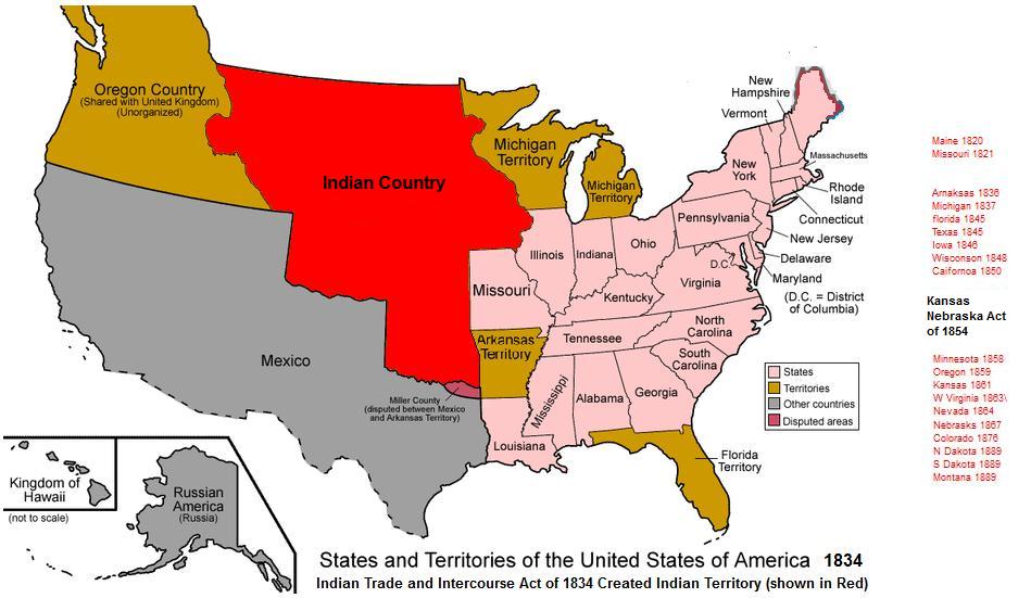
The Louisiana Purchase was one of several historical territorial
additions to the United States.
In 1803 the United States of America agreed to purchase
France's claim to the territory of Louisiana for a total of $15 million
(less than 3 cents per acre).
President Thomas Jefferson doubted the legality of the
purchase. However, the chief negotiator, Robert R. Livingston believed
that the 3rd article of the treaty providing for the Louisiana Purchase
would be acceptable to congress. The 3rd article stated, in part:
| the inhabitants of the ceded territory shall be incorporated
in the Union of the United States, and admitted as soon as possible, according
to the principles of the Federal Constitution, to the enjoyment of all
the rights, advantages, and immunities of citizens of the United States;
and in the meantime they shall be maintained and protected in the free
enjoyment of their liberty, property, and the religion which they profess. |
|
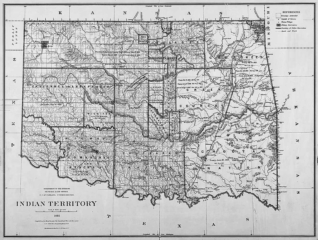
1885
1891
|
Which committed the US government to the ultimate, but not
to the immediate, admission of the territory as multiple states, and postponed
its incorporation into the Union to the pleasure of Congress
After the Louisiana Purchase in 1803, President Thomas
Jefferson and his successors viewed much of the land west of the Mississippi
River as a place to resettle the Native Americans, so that white settlers
would be free to live in the lands east of the river. Indian removal became
the official policy of the United States government with the passage of
the 1830 Indian Removal Act, formulated by President Andrew Jackson.
When Louisiana became a state in 1812, the remaining territory
was renamed Missouri Territory to avoid confusion. Arkansas Territory,
which included the present State of Arkansas plus most of the state of
Oklahoma, was created out of the southern part of Missouri Territory in
1819. Originally the western border of Missouri was intended to go due
south to the Red River. However, during negotiations with the Choctaw in
1820, Andrew Jackson ceded more of Arkansas Territory to the Choctaw than
he realized, resulting in a bend in the border between Arkansas and Oklahoma
at Ft. Smith, Arkansas. The General Survey Act of 1824, allowed a survey
that established the western border of Arkansas Territory well inside the
present state of Oklahoma, where the Choctaw and Cherokee tribes had previously
begun to settle. The two nations objected strongly, and in 1828 a new survey
redefined the western Arkansas border. Thus, the "Indian zone" would cover
the present states of Oklahoma, Kansas, Nebraska and part of Iowa.
Relocation and treaties
Before the 1871 Indian Appropriations Act, much of what
was called Indian Territory was a large area in the central part of the
United States whose boundaries were set by treaties between the US Government
and various indigenous tribes. After 1871, the Federal Government dealt
with Indian Tribes through statute; the 1871 Indian Appropriations Act
also stated that. [n]o Indian nation or tribe within the territory of
the United States shall be acknowledged or recognized as an independent
nation ....
The Indian Appropriations Act also made it a federal crime
to commit murder, manslaughter, rape, assault with intent to kill, arson,
burglary, and larceny within any Territory of the United States. The Supreme
Court affirmed the action in 1886 in United States v. Kagama, which affirmed
that the US Government has Plenary power over Native American tribes within
its borders using the rationalization that The power of the general government
over these remnants of a race once powerful... is necessary to their protection
as well as to the safety of those among whom they dwell While the federal
government of the United States had previously recognized the Indian Tribes
as semi-independent, it has the right and authority, instead of controlling
them by treaties, to govern them by acts of Congress, they being within
the geographical limit of the United States... The Indians owe no allegiance
to a State within which their reservation may be established, and the State
gives them no protection.
Reductions of area
White settlers continued to flood into Indian country.
As the population increased, the homesteaders could petition Congress for
creation of a territory. This would initiate an Organic Act which established
a three-part territorial government. The governor and judiciary were appointed
by the President of the United States, while the legislature was elected
by citizens residing in the territory. One elected representative was allowed
a seat in the U. S. House of Representatives. The federal government took
responsibility for territorial affairs. Later, the inhabitants of the territory
could apply for admission as a full state. No such action was taken for
the so-called Indian Territory, so that area was not treated as a legal
territory.
The reduction of the land area of Indian Territory (or
Indian Country, as defined in the Indian Intercourse Act of 1834), the
successor of Missouri Territory began almost immediately after its creation
with:
Wisconsin Territory formed in 1836 from lands east of
the Mississippi and between the Mississippi and Missouri rivers. Wisconsin
became a state in 1848
Iowa Territory (land between the Mississippi and Missouri
Rivers) was split from Wisconsin Territory in 1838 and became a state in
1846.
Minnesota Territory was split from Iowa Territory in 1849
and became a state in 1858
Dakota Territory was organized in 1861 from the northern
part of Indian Country and Minnesota Territory. The name refers to the
Dakota branch of the Sioux tribes.
North Dakota and South Dakota became states in 1889.
Present-day states of Montana and Wyoming were also part
of the Dakota Territory
Indian Country was reduced to the approximate boundaries
of the current state of Oklahoma by the KansasNebraska Act of 1854, which
created Kansas Territory and Nebraska Territory. The key boundaries of
the territories were:
40° N the current KansasNebraska
border
37° N the current Kansas Oklahoma
(Indian Territory) border
Kansas became a state in 1861, and Nebraska became a state
in 1867. In 1890 the Oklahoma Organic Act created Oklahoma Territory out
of the western part of Indian Territory, in anticipation of admitting both
Indian Territory and Oklahoma Territory as a single State of Oklahoma.
|
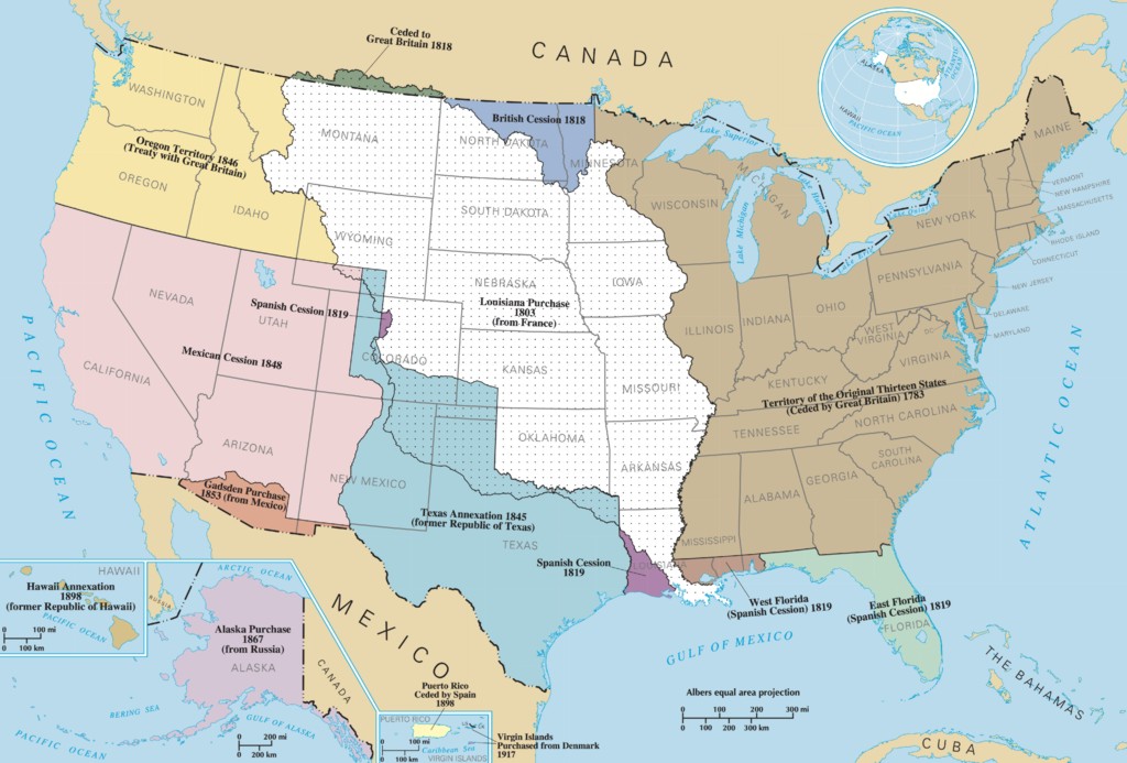
Louisiana Purchase |
At the beginning of the Civil War, Indian Territory had
been essentially reduced to the boundaries of the present-day U.S. state
of Oklahoma, and the primary residents of the territory were members of
the Five Civilized Tribes or Plains tribes that had been relocated to the
western part of the territory on land leased from the Five Civilized Tribes.
In 1861, the U.S. abandoned Fort Washita, leaving the Chickasaw and Choctaw
Nations defenseless against the Plains tribes. Later the same year, the
Confederate States of America signed a Treaty with Choctaws and Chickasaws.
Ultimately, the Five Civilized Tribes and other tribes that had been relocated
to the area, signed treaties of friendship with the Confederacy.
During the Civil War, Congress gave the U.S. president
the authority to, if a tribe was "in a state of actual hostility to the
government of the United States... and, by proclamation, to declare all
treaties with such tribe to be abrogated by such tribe"(25 USC Sec. 72).
Prior to the Civil War, the Pottawatomie Massacre (May
2425, 1856) was one of the many bloody episodes in Kansas preceding which
came to be known collectively as Bleeding Kansas.
Members of the Five Civilized Tribes, and others who had
relocated to the Oklahoma section of Indian Territory, fought primarily
on the side of the Confederacy during the American Civil War in Indian
territory. Brigadier General Stand Watie, a Confederate commander of the
Cherokee Nation, became the last Confederate general to surrender in the
American Civil War, near the community of Doaksville on June 23, 1865.
The Reconstruction Treaties signed at the end of the Civil War fundamentally
changed the relationship between the tribes and the U.S. government.
The Reconstruction Era of the United States played out
differently in Indian Territory and for Native Americans than for the rest
of the country. In 1862, Congress passed a law that allowed the president,
by proclamation, to cancel treaties with Indian Nations siding with the
Confederacy (25 USC 72).." The United States House Committee on Territories
(created in 1825) was examining the effectiveness of the policy of Indian
removal, which was after the war considered to be of limited effectiveness.
It was decided that a new policy of Assimilation would be implemented.
To implement the new policy, the Southern Treaty Commission was created
by Congress to write new treaties with the Tribes siding with the Confederacy.
After the Civil War the Southern Treaty Commission re-wrote
treaties with tribes that sided with the Confederacy, reducing the territory
of the Five Civilized Tribes and providing land to resettle Plains Indians
and tribes of the mid-west. General components of replacement treaties
signed in 1866 include:
| Abolished slavery
Provided amnesty for siding with Confederate States of
America
Agreed to legislation that Congress and the President
"may deem necessary for the better administration of justice and the protection
of the rights of person and property within the Indian territory."
Tribes grant right of way for rail roads authorized by
Congress; A Land patent, or "first-title deed" to alternate sections of
land adjacent to rail roads would be granted to the rail road upon completion
of each 20 mile section of track and water stations
Within each county, a quarter section of land shall be
held in trust for the establishment of seats of justice therein, and also
as many quarter-sections as the said legislative councils may deem proper
for the permanent endowment of schools
Provided for each man, woman, and child to receive 160
acres of land as an allotment.
A Land patent, or "first-title deed" shall be issued as
evidence of allotment, "issued by the President of the United States, and
countersigned by the chief executive officer of the nation in which the
land lies"
Declared treaties and parts of treaties inconsistent with
the replacement treaties to be null and void. |
Medicine Lodge Treaty is the overall name for three treaties
signed in Medicine Lodge, Kansas between the US government and southern
Plains Indian tribes who would ultimately reside in the western part of
Indian Territory (ultimately Oklahoma Territory). The first treaty was
signed October 21, 1867, with the Kiowa and Comanche tribes. The second,
with the Kiowa-Apache, was signed the same day. The third treaty was signed
with the Southern Cheyenne and Arapaho on October 28.
Another component of assimilation was homesteading. The
Homestead Act of 1862, was signed into law by President Abraham Lincoln.
The Act gave an applicant freehold title to an area called a "homestead"
- typically 160 acres (65 hectares or one-fourth section) of undeveloped
federal land. Within Indian Territory, as lands were removed from communal
tribal ownership, a Land patent (or first-title deed) was given to tribal
members. The remaining land was sold on a first-come basis (typically by
Land run, with settlers also receiving a Land patent type deed. For these
now former Indian lands, the General Land Office distributed the sales
funds to the various tribal entities, according to previously negotiated
terms.
Oklahoma Territory, end of territories upon statehood
The Oklahoma organic act of 1890 created an organized
incorporated territory of the United States of Oklahoma Territory, with
the intent of combining the Oklahoma and Indian territories into a single
State of Oklahoma. The citizens of Indian Territory tried, in 1905, to
gain admission to the union as the State of Sequoyah, but were rebuffed
by Congress and an Administration which did not want two new Western states,
Sequoyah and Oklahoma. Theodore Roosevelt then proposed a compromise that
would join Indian Territory with Oklahoma Territory to form a single state.
This resulted in passage of the Oklahoma Enabling Act, which President
Roosevelt signed June 16, 1906. empowered the people residing in Indian
Territory and Oklahoma Territory to elect delegates to a state constitutional
convention and subsequently to be admitted to the union as a single state.
Citizens then joined to seek admission of a single state to the Union.
With Oklahoma statehood in November 1907, Indian Territory was extinguished.
Tribes - Five Civilized Tribes
What are today known as the Five Civilized Tribes originated
in the Southeastern United States, and were probably descendents of the
Mississippian culture, an agrarian culture that grew crops of corn and
beans, with urban centers and regional chiefdoms, of which the greatest
was the settlement known as Cahokia, in present-day Illinois. Stratified
societies developed, with hereditary religious and political elites, and
flourished in what is now the Midwestern, Eastern, and Southeastern United
States from 800 to 1500 CE.
Between 1814 and 1840, the Five Civilized Tribes had gradually
ceded most of their lands in the Southeast section of the US through a
series of treaties. The southern part of Indian Country (what eventually
became the State of Oklahoma) served as the destination for the policy
of Indian Removal, a policy pursued intermittently by American presidents
early in the 19th century, but aggressively pursued by President Andrew
Jackson after the passage of the Indian Removal Act of 1830. The Five Civilized
Tribes in the South were the most prominent tribes displaced by the policy,
a relocation that came to be known as the Trail of Tears during the Choctaw
removals starting in 1831. The trail ended in what is now Arkansas and
Oklahoma, where there were already many Indians living in the territory,
as well as whites and escaped slaves. Other tribes, such as the Delaware,
Cheyenne, and Apache were also forced to relocate to the Indian territory.
The Five Civilized Tribes established tribal capitals
in the following towns:
Cherokee Nation - Tahlequah
Chickasaw Nation - Tishomingo
Choctaw Nation - Tuskahoma (later
moved to Durant)
Muscogee (Creek) Nation - Okmulgee
Seminole Nation - Wewoka
The Five Civilized Tribes set up towns such as Tulsa,
Ardmore, Muskogee, which became some of the larger towns in the state.
They also brought their African slaves to Oklahoma, which added to the
black American population in the state.
| Beginning in 1783 the Choctaw signed a series of treaties
with first the British and then the Americans. The Treaty of Dancing Rabbit
Creek was the first removal treaty carried into effect under the Indian
Removal Act, ceding land in the future state of Mississippi in exchange
for land in the future state of Oklahoma, resulting in the Choctaw Trail
of Tears.
The Creek nation began the process of moving to Indian
Territory with the 1814 Treaty of Fort Jackson and the Treaty of Washington
(1826). In the 1832 Treaty of Cusseta, ceded all Creek claims east of the
Mississippi River to the United States.
The 1835 the Treaty of New Echota established terms under
which the entire Cherokee Nation was expected to cede its territory in
the Southeast and move to Indian Territory. Although the treaty was not
approved by the Cherokee National Council, it was ratified by the U.S.
Senate and resulted in the Cherokee Trail of Tears.
The Chickasaw, rather than receiving land grants in exchange
for ceding Aboriginal land rights, received financial compensation. The
tribe negotiated a $3 million payment for their native lands (which was
not fully funded by the US for 30 years). In 1836, the Chickasaw agreed
to purchase land from the previously removed Choctaws for $530,000.
Seminole People, originally from the present-day state
of Florida, signed the Treaty of Payne's Landing in 1832, in response to
the 1830 Indian Removal Act, that forced the tribes to move to Indian Territory
in present-day Oklahoma. In October 1832 a delegation arrived in Indian
Territory and conferred with the Muscogee (Creek) Nation tribe that had
already been removed to the area. In 1833 an agreement was signed at Fort
Gibson (on the Arkansas River just east of Muskogee, Oklahoma), accepting
the area in the western part of the Creek Nation. However, the chiefs in
Florida did not agree to the agreement. In spite of the disagreement, the
treaty was ratified by the Senate in April 1934. |
The Western Lakes Confederacy was a loose confederacy
of tribes around the Great Lakes region following the American Revolutionary
War organized to resist the expansion of the United States into the Northwest
Territory. Members of the confederacy were ultimately removed to the present-day
Oklahoma, including Shawnee, Delaware Tribe of Indians also called Lenape,
Miami, and Kickapoo.
The area of Pottawatomie County, Oklahoma was used to
resettle the Iowa tribe, Sac and Fox, Absentee Shawnee, Potawatomi and
Kickapoo tribes. There were five civilized tribes
The Council of Three Fires is an alliance of the Ojibwe
or Chippewa, Ottawa, and Potawatomi tribes. In the first of two 1829 Treaty
of Prairie du Chien, the tribes of the Council of Three Fires ceded to
the United States their lands in Illinois Michigan and Wisconsin. The 1833
Treaty of Chicago forced the members of the Council of Three Fires to move
first to present-day Iowa, then Kansas and Nebraska, and ultimately Oklahoma.
The Illinois Potawatomi moved to present-day Nebraska
and the Indiana Potawatomi moved to present-day Osawatomie, Kansas, an
event know as the Potawatomi Trail of Death. The group settling in Nebraska
adapted to the Plains Indian culture but the group settling in Kansas remained
steadfast to their Woodlands culture. In 1867 part of the Kansas group
negotiated the Treaty of Washington with the Potawatomi in which the Kansas
Prairie Band Potawatomi Nation split and part of their Kansas land was
sold, purchasing land near present-day Shawnee, Oklahoma, becoming the
Citizen Potawatomi Nation.
The Ottawa tribe first purchased lands near Ottawa, Kansas
until 1867 when they sold their lands in Kansas and purchase land in an
area administered by the Quapaw Indian Agency in Ottawa County, Oklahoma,
becoming the Ottawa Tribe of Oklahoma.
Iroquois Confederacy
The Iroquois Confederacy was an alliance of tribes, originally
from the New York state area consisting of the Seneca tribe, Cayuga tribe,
Onondaga (tribe), Oneida tribe, Mohawk nation, and Tuscarora (tribe). In
pre-revolutionary war days, the Confederacy expanded to areas from Kentucky
and Virginia north. All of the members of the Confederacy, except Oneida,
allied with the British during the Revolutionary War, and were forced to
cede their land after the war. Most moved to Canada after the Treaty of
Canandaigua in 1794, some remained in New York, and some moved to Ohio,
joining the Shawnee.
The 1838 and 1842 Treaties of Buffalo Creek were treaties
with New York Indians, such as the Seneca Nation, Mohawk nation, Cayuga
nation, and Oneida Indian Nation, which covered land sales of tribal reservations
under the US Indian Removal program, by which they planned to move most
eastern tribes to Indian Territory. Initially, the tribes were moved to
the present state of Kansas, and later to Oklahoma in the Land administered
by the Quapaw Indian Agency.
Plains Indian tribes
| The Plains Indians are an archetype in art and literature
for all Native Americans. Initially, some Plains Indian tribes were agrarian
and others were hunter-gathers. Some tribes used the dog as a Draft animal
to pull a small Travois (or sleigh) to help move from place to place. However,
in the 18th century most plains tribes adopted the Horse culture and became
nomadic. The Tipi (also tepee and teepee, and not to be confused with the
Wigwam of the tribes of the Northeast and the West) was used by Plains
Indians as a dwelling unit because they were portable and could be reconstructed
quickly when the tribe settled in a new area for hunting or a Pow wow (a
periodic gathering of medicine men and/or spiritual leaders).
Historically, the Arapaho had assisted the Cheyenne and
Lakota people in driving the Kiowa and Comanche south from the Northern
Plains, their hunting area ranged from Montana to Texas. Kiowa and Comanche
controlled a vast expanse of territory from the Arkansas River to the Brazos
River. By 1840 many plains tribes had made peace with each other and developed
Plains Indian Sign Language as a means of communicate with their allies. |
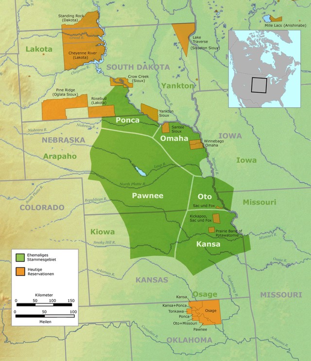 |
| Kaw speak one of the Siouan languages and were originally
from the Kansas area (with Kansas being derived from the name of the tribe.)
The Kaw are closely related to the Osage Nation and Ponca tribes (who first
settled in Nebraska), being from the same tribe before migrating from the
Ohio valley in the mid-17th century. On June 4, 1873, the Kaw removed themselves
from Kansas to an area that would become Kay County, Oklahoma. Tribal headquarters
is in Kaw City, Oklahoma.
Ponca speak one of the Siouan languages and are closely
related to the Osage Nation and Kaw tribes. The Ponca tribe was never at
war with the US and signed the first peace treaty in 1817. In 1858 the
Ponca signed a treaty, ceding part of their land to the United States in
return for annuities, payment of $1.25 per acre from settlers, protection
from hostile tribes and a permanent reservation home on the Niobrara River
at the confluence with the Missouri River. In the 1868 US-Sioux Treaty
of Fort Laramie [26] the US mistakenly included Ponca lands in present-day
Nebraska in the Great Sioux Reservation of present-day South Dakota. Conflict
between the Ponca and the Sioux/Lakota, who now claimed the land as their
own by US law, forced the US to remove the Ponca from their own ancestral
lands to Indian Territory in 1877, parts of the current Kay and Noble counties
in Oklahoma. The land proved to be less than desirable for agriculture
and many of the tribe moved back to Nebraska. In 1881, the US returned
26,236 acres (106.17 km2) of Knox County, Nebraska, to the Ponca, and about
half the tribe moved back north from Indian Territory. Today, the Ponca
Tribe of Indians of Oklahoma have their headquarters in Ponca City, Oklahoma.
Otoe-Missouria Tribe of Indians, speak one of the Siouan
languages and part of a group commonly known as the Ho-Chunk (or Winnebago)
moved to Oklahoma Territory, The tribe is made up of Otoe and Missouria
Indians, is located in part of Noble County, Oklahoma with tribal offices
in Red Rock, Oklahoma. Both tribes originated in the Great Lakes region
by the 16th century had settled near the Missouri and Grand Rivers in Missouri.
Cheyenne and Arapaho Tribes of Oklahoma are a united tribe
of the Southern Arapaho and the Southern Cheyenne people, headquartered
in Concho, Oklahoma (a rural suburb of Oklahoma City.)
Cheyenne were originally an agrarian people in present-day
Minnesota and speak an Algonquian language. In 1877, after the Battle of
the Little Bighorn (in present-day Montana) a group of Cheyenne were escorted
to Indian Territory (present-day Oklahoma). However, they were not used
to the dry heat climate and food was insufficient and of poor quality.
A group of Cheyenne left the territory without permission to travel back
north. Ultimately, the military gave up attempting to relocate the Northern
Cheyenne back to Oklahoma and a Northern Cheyenne reservation was established
in Montana
Arapaho came from the present-day Saskatchewan, Montana,
and Wyoming area, and speak an Algonquian language.
Comanche lived in the upper Platte River in Wyoming breaking
off from the Shoshone people in the late 17th century, and speak a Numic
language of the Uto-Aztecan family. A nomadic people, the Comanche never
developed a political idea of forming a nation or tribe. In 1875,
the last free band of Comanches, led by Quanah Parker, surrendered and
moved to the Fort Sill reservation in Oklahoma. The Comanche
(and other tribes) signed a treaty of friendship with the US in 1835. An
additional treaty was signed in 1846. The Comanche Nation is headquartered
in Lawton, Oklahoma.
Pawnee speak a Caddoan language. Originally from the area
around Omaha, Nebraska. In the 16th century Francisco Vásquez de
Coronado had an encounter with a Pawnee chief. In the 1830s exposure to
infectious diseases, such as measles, smallpox and cholera decimated the
tribe. The 1857 Treaty with the Pawnee,[30] their range was reduced to
an area around Nance County, Nebraska. In 1874 the tribe was relocated
to land in the Cherokee Outlet in Oklahoma Territory, in Pawnee County,
Oklahoma. Tribal Headquarters are in Pawnee, Oklahoma.
Tonkawa speak a language isolate, with no known related
languages, seem to have inhabited northeastern Oklahoma in the 15th century.
However, by the 18th century the Plains Apache pushed the Tonkawa south
to what is now southern Texas. After Texas was admitted as a State, the
Tonkawa signed the 1846 Treaty with the Comanche and other Tribes at Council
Springs, Texas. After siding with the Confederacy, acting as scouts for
the Texas Rangers, the Tonkawa Massacre, occurring near Lawton, Oklahoma
killed about ½ of the tribe. In 1891 the Tonkawa were offered allotments
in the Cherokee Outlet near present-day Tonkawa, Oklahoma.
|
Because Oklahoma is situated between the Great Plains
and the Ozark Plateau in the Gulf of Mexico watershed, the western part
of the state is subjected to extended periods of drought and high winds
in the region may then generate Dust storms, and the eastern part of the
state is humid subtropical climate zone. Tribes that are indigenous to
the current-day State of Oklahoma include both agrarian tribes settling
in the eastern part of the state and Hunter-gatherer tribes adopting the
Horse culture settling in the western part of the state. These indigenous
tribes are the only tribes currently residing in the State of Oklahoma
that would qualify as having Aboriginal title to their land. Other tribes
received their land either by treaty via Land grant from the Federal government
of the United States or they purchased the land receiving Fee simple title.
Agrarian tribes
Caddo people speak a Caddoan language and is a confederation
of several tribes who traditionally inhabited much of what is now East
Texas, northern Louisiana and portions of southern Arkansas and Oklahoma.
The tribe is part of the Caddoan Mississippian culture and thought to be
an extension of Woodland period peoples who started inhabiting the area
around 200 BC. In an 1835 Treaty made at the agency-house in the
Caddo nation and State of Louisiana, the Caddo Nation sold their tribal
lands to the US. In 1846 the Caddo along with several other tribes signed
a treaty that made the Caddo a protectorate of the US and established framework
of a legal system between the Caddo and the US. Tribal headquarters are
in Binger, Oklahoma.
Wichita people speak a Caddoan language. The Wichita have
lived in the eastern Great Plains from the Red River north to Nebraska
for at least 2,000 years. The early Wichita people were hunters and gatherers
who slowly adopted agriculture, about 900 AD farming villages began to
appear on terraces above the Washita River and South Canadian River in
Oklahoma. The Wichita (and other tribes) signed a treaty of friendship
with the US in 1835. The tribes headquarters are in Anadarko, Oklahoma.
Hunter-Gatherer tribes
Kiowa originated in the area of Glacier National Park,
Montana and speak a Kiowa-Tanoan language. In the 18th century the Kiowa
and Plains Apache moved to the plains adjacent to the Arkansas River in
Colorado and Kansas and the Red River of the Texas Panhandle and Oklahoma.
In 1837 the Kiowa (and other tribes) signed a treaty of friendship with
the US that established a framework for legal system administered by the
US. Provided for trade between Republics of Mexico and Texas. Tribal headquarters
are in Carnegie, Oklahoma
Plains Apache or Kiowa Apache, a branch of the Apache
that lived in the upper Missouri River area and speak one of the Southern
Athabaskan languages. In the 18th century, the branch migrated south and
adopted the lifestyle of the Kiowa. Tribal headquarters are in Anadarko,
Oklahoma.
Osage Nation speak one of the Siouan languages and originated
in present-day Kentucky. As the Iroquois moved south, the Osage moved west.
By the early 18th century the Osage had become the dominant power in the
Oklahoma, Arkansas, Missouri and Kansas, controlling much of the land between
the Red River and Missouri River. From 1818 to 1825 a series of treaties
reduced the Osage lands to the Independence, Kansas. With the 1870 Drum
Creek Treaty, the Kansas land was sold for $1.25 per acre and the Osage
purchased 1,470,000 acres (5,900 km2) in Indian Territorys Cherokee Outlet,
the current Osage County, Oklahoma. While the Osage did not escape the
federal policy of allotting communal tribal land to individual tribal members,
they negotiated to retain communal mineral rights to the reservation lands.
These were later found to have great amounts of crude oil, from which tribal
members benefited from royalty revenues from oil development and production.
Tribal headquarters are in Pawhuska, Oklahoma.
Government
During the Reconstruction Era when the size of Indian
Territory was reduced, the renegotiated treaties with the Five Civilized
Tribes and the tribes occupying the land of the Quapaw Indian Agency contained
provisions for a government structure in Indian Territory. Replacement
treaties signed in 1866 contained provisions for:
Indian Territory Legislature would
have proportional representation from tribes over 500 members
Laws take effect unless suspended
by Secretary of the Interior or President of the United States
No laws shall be inconsistent with
the United States Constitution, or laws of Congress, or treaties of the
United States
No legislation regarding matters
pertaining to the legislative, judicial, or other organization, laws, or
customs of the several tribes or nations,
except as herein provided
for
Superintendent of Indian Affairs (or
appointee) is the presiding officer of the Indian Territory Legislature
Secretary of Interior appoints secretary
of the Indian Territory Legislature
A court or courts may be established
in Indian Territory with such jurisdiction and organization as Congress
may prescribe: Provided that
the same shall not interfere
with the local judiciary of either of said nations.
No session in any one year shall exceed
the term of thirty days, and provided that the special sessions may be
called whenever, in the
judgment of the Secretary
of the Interior, the interests of said tribes shall require it
In a continuation of the new policy, the 1890 Oklahoma
organic act extended civil and criminal laws of Arkansas over the Indian
Territory,and extended the laws of Nebraska over Oklahoma Territory.
|