| Yellowstone National Park From Wikipedia
Yellowstone National Park, established by the U.S. Congress
and signed into law by President Ulysses S. Grant on March 1, 1872, is
a national park located primarily in the U.S. state of Wyoming, though
it also extends into Montana and Idaho. Yellowstone was the first national
park in the world, and is known for its wildlife and its many geothermal
features, especially Old Faithful Geyser, one of the most popular features
in the park. It has many types of ecosystems, but the subalpine forest
is dominant.
| Native Americans have lived in the Yellowstone region
for at least 11,000 years. The region was bypassed during the Lewis and
Clark Expedition in the early 1800s. Aside from visits by mountain men
during the early to mid-1800s, organized exploration did not begin until
the late 1860s. The U.S. Army was commissioned to oversee the park just
after its establishment. In 1917, administration of the park was transferred
to the National Park Service, which had been created the previous year.
Hundreds of structures have been built and are protected for their architectural
and historical significance, and researchers have examined more than 1,000
archaeological sites.
Yellowstone National Park spans an area of 3,468 square
miles (8,980 km2), comprising lakes, canyons, rivers and mountain ranges. |
..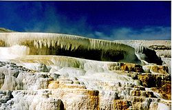
Canary Springs |
Yellowstone Lake is one of the largest high-altitude lakes
in North America and is centered over the Yellowstone Caldera, the largest
supervolcano on the continent. The caldera is considered an active volcano;
it has erupted with tremendous force several times in the last two million
years. Half of the world's geothermal features are in Yellowstone, fueled
by this ongoing volcanism. Lava flows and rocks from volcanic eruptions
cover most of the land area of Yellowstone. The park is the centerpiece
of the Greater Yellowstone Ecosystem, the largest remaining, nearly intact
ecosystem in the Earth's northern temperate zone.
Hundreds of species of mammals, birds, fish and reptiles
have been documented, including several that are either endangered or threatened.
The vast forests and grasslands also include unique species of plants.
Grizzly Bears, wolves, and free-ranging herds of bison and elk live in
the park. Forest fires occur in the park each year; in the large forest
fires of 1988, nearly one third of the park burned. Yellowstone has numerous
recreational opportunities, including hiking, camping, boating, fishing
and sightseeing. Paved roads provide close access to the major geothermal
areas as well as some of the lakes and waterfalls. During the winter, visitors
often access the park by way of guided tours that use either snow coaches
or snowmobile.
History
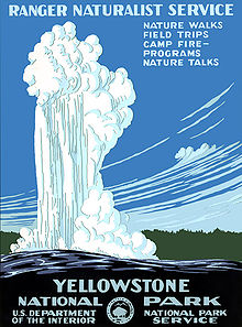 .... ....
Historical poster of Yellowstone from 1938 |
The park is located at the headwaters of the Yellowstone
River, from which it takes its historical name. Near the end of the 18th
century, French trappers named the river "Roche Jaune," which is probably
a translation of the Minnetaree name "Mi tsi a-da-zi" (Rock Yellow River).
Later, American trappers rendered the French name in English as "Yellow
Stone." Although it is commonly believed that the river was named for the
yellow rocks seen in the Grand Canyon of the Yellowstone, the Native American
name source is not clear.
The human history of the park begins at least 11,000 years
ago when aboriginal Americans first began to hunt and fish in the region.
During the construction of the post office in Gardiner, Montana, in the
1950s, an obsidian projectile point of Clovis origin was found that dated
from approximately 11,000 years ago. These Paleo-Indians, of the Clovis
culture, used the significant amounts of obsidian found in the park to
make such cutting tools and weapons. Arrowheads made of Yellowstone obsidian
have been found as far away as the Mississippi Valley, indicating that
a regular obsidian trade existed between local tribes and tribes farther
east. By the time white explorers first entered the region during the Lewis
and Clark Expedition in 1805, they encountered the Nez Perce, Crow and
Shoshone tribes. While passing through present day Montana, the expedition
members were informed of the Yellowstone region to the south, but they
did not investigate it.
In 1806, John Colter, a member of the Lewis and Clark
Expedition, left to join a group of fur trappers. After splitting up with
the other trappers in 1807, Colter passed through a portion of what later
became the park, during the winter of 18071808.
. |
He observed at least one geothermal area in the northeastern
section of the park, near Tower Fall. After surviving wounds he suffered
in a battle with members of the Crow and Blackfoot tribes in 1809, he gave
a description of a place of "fire and brimstone" that was dismissed by
most people as delirium. The supposedly imaginary place was nicknamed "Colter's
Hell." Over the next forty years, numerous reports from mountain men and
trappers told of boiling mud, steaming rivers and petrified trees, yet
most of these reports were believed at the time to be myth.
After an 1856 exploration, mountain man Jim Bridger (also
believed to be the first or second European American to have seen the Great
Salt Lake) reported observing boiling springs, spouting water, and a mountain
of glass and yellow rock. These reports were largely ignored because Bridger
was known for being a "spinner of yarns". In 1859, Captain William F. Raynolds,
U.S. Army surveyor embarked on a two year survey of the northern Rockies.
After wintering in Wyoming, in May 1860, Raynolds and his party which included
naturalist Ferdinand Vandeveer Hayden and guide Jim Bridger attempted to
cross the Continental Divide over Two Ocean Plateau from the Wind River
drainage in northwest Wyoming. Heavy spring snows prevented their passage
but had they been able to traverse the divide, the party would have been
the first organized survey to enter the Yellowstone region. The American
Civil War hampered further organized explorations until the late 1860s.
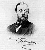
Ferdinand V. Hayden American geologist who convinced
Congress to make Yellowstone a National Park.
| The first detailed expedition to the Yellowstone area
was the CookFolsomPeterson Expedition of 1869, which consisted of three
privately funded explorers. The Folsom party followed the Yellowstone River
to Yellowstone Lake. The members of the Folsom party kept a journal and
based on the information it reported, a party of Montana residents organized
the Washburn-Langford-Doane Expedition in 1870. It was headed by the surveyor-general
of Montana Henry Washburn, and included Nathaniel P. Langford (who later
became known as "National Park" Langford) and a U.S. Army detachment commanded
by Lt. Gustavus Doane.
The expedition spent about a month exploring the region,
collecting specimens, and naming sites of interest. A Montana writer and
lawyer named Cornelius Hedges, who had been a member of the Washburn expedition,
proposed that the region should be set aside and protected as a National
Park; he wrote a number of detailed articles about his observations for
the Helena Herald newspaper between 1870 and 1871. |
. |
Hedges essentially restated comments made in October 1865
by acting Montana Territorial Governor Thomas Francis Meagher, who had
previously commented that the region should be protected. Others made similar
suggestions. In an 1871 letter from Jay Cooke to Ferdinand Hayden, Cooke
wrote that his friend, Congressman William D. Kelley had also suggested
"Congress pass a bill reserving the Great Geyser Basin as a public park
forever".
Park creation
| In 1871, eleven years after his failed first effort,
F.V. Hayden was finally able to make another attempt to explore the region.
With government sponsorship, Hayden returned to Yellowstone region with
a second, larger expedition, the Hayden Geological Survey of 1871. He compiled
a comprehensive report on Yellowstone, which included large-format photographs
by William Henry Jackson, as well as paintings by Thomas Moran. His report
helped to convince the U.S. Congress to withdraw this region from public
auction, on March 1, 1872, President Ulysses S. Grant signed The Act of
Dedication law that created Yellowstone National Park.
Ferdinand V. Hayden , while not the only person to have
thought of creating a park in the Yellowstone region, was the parks first
and most enthusiastic advocate. He believed in setting aside the area
as a pleasure ground for the benefit and enjoyment of the people and warned
that there were those who would come and make merchandise of these beautiful
specimens. Worrying the area could face the same fate as Niagara Falls,
he conclude the sight should be as free as the air or Water.
In his report to the Committee on Public Lands, he concluded
that if the bill failed to become law, the vandals who are now waiting
to enter into this wonder-land, will in a single season despoil , beyond
recovery, these remarkable curiosities, which have requited all the cunning
skill of nature thousands of years to prepare. |
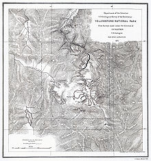
An old contour map showing mountainous
terrain and a large lake F.V. Hayden's map
of Yellowstone National Park, 1871. |
Hayden and his 1871 party recognized that Yellowstone
was a priceless treasure, which would become rarer with time. He wished
for others to see and experience it as well. Eventually the railroads and
eventually the automobile would make that possible The Park was not set
aside strictly for ecological purposes, however the designation pleasure
ground was not an invitation to create an amusement park. Hayden imagined
something akin to the scenic resorts and baths in England, Germany and
Switzerland.
-------------
THE ACT OF DEDICATION
AN ACT to set apart a certain tract
of land lying near the headwaters of the Yellowstone River as a public
park. Be it enacted by the Senate and House of Representatives of the United
States of America in Congress assembled, That the tract of land in the
Territories of Montana and Wyoming .... is hereby reserved and withdrawn
from settlement, occupancy, or sale under the laws of the United States,
and dedicated and set apart as a public park or pleasuring ground for the
benefit and enjoyment of the people; and all persons who shall locate,
or settle upon, or occupy the same or any part thereof, except as hereinafter
provided, shall be considered trespassers and removed there from...
Approved March 1, 1872.
Signed by:
* JAMES G.
BLAINE, Speaker of the House.
* SCHUYLER
COLFAX, Vice-President of the United States and President of the Senate.
* ULYSSES
S. GRANT, President of the United States.
-------------
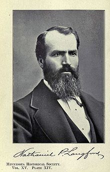 . .
(1870) Portrait of Nathaniel P. Langford,
the first superintendent of the park |
There was considerable local opposition to the Yellowstone
National Park during its early years: some locals feared that the regional
economy would be unable to thrive if there remained strict federal prohibitions
against resource development or settlement within park boundaries; local
entrepreneurs advocated reducing the size of the park so that mining, hunting,
and logging activities could be developed and numerous bills were introduced
into Congress by Montana representatives who sought to remove the federal
land-use restrictions.
After the park's official formation, Nathaniel Langford
was appointed as the park's first superintendent in 1872. He served for
five years but was denied a salary, funding, and staff. Langford lacked
the means to improve the land or properly protect the park, and without
formal policy or regulations, he had few legal methods to enforce such
protection. This left Yellowstone vulnerable to poachers, vandals, and
others seeking to raid its resources. He addressed the practical problems
park administrators faced in the 1872 Report to the Secretary of the Interior
and correctly predicted that Yellowstone will become a major international
attraction deserving the continuing stewardship of the government. In 1875,
Colonel William Ludlow, who had previously explored areas of Montana under
the command of George Armstrong Custer, was assigned to organize and lead
an expedition to Montana and the newly established Yellowstone Park. Observations
about the lawlessness and exploitation of park resources were included
in Ludlow's Report of a Reconnaissance to the Yellowstone Nation Park.
The report included letters and attachments by other expedition members,
including naturalist and mineralogist George Bird Grinnell. Grinnell documented
the poaching of buffalo, deer, elk and antelope for hides. "It is estimated
that during the winter of 18741875, not less than 3,000 buffalo and mule
deer suffer even more severely than the elk, and the antelope nearly as
much."
|
As a result, Langford was forced to step down in 1877. Having
traveled through Yellowstone and witnessed land management problems first
hand, Philetus Norris volunteered for the position following Langford's
exit. Congress finally saw fit to implement a salary for the position,
as well as to provide a minimal funding to operate the park. Norris used
these funds to expand access to the park, building numerous crude roads
and facilities.
In 1880, Harry Yount was appointed as a gamekeeper to
control poaching and vandalism in the park. Yount had previously spent
a number of years exploring the mountain country of present-day Wyoming,
including the Grand Tetons, after joining Dr. Haydens Geological Survey
in 1873. Today, he is considered the first national park ranger, and Younts
Peak, located at the head of the Yellowstone River, was named in his honor.
However, these measures still proved to be insufficient in protecting the
park, as neither Norris, nor the three superintendents who followed, were
given sufficient manpower or resources.
| The Northern Pacific Railroad built a train station in
Livingston, Montana, connecting to the northern entrance in the early 1880s,
which helped to increase visitation from 300 in 1872 to 5,000 in 1883.
Visitors in these early years were faced with poor roads and limited services,
and most access into the park was on horse or via stagecoach. By 1908 visitation
increased enough to also attract a Union Pacific Railroad connection to
West Yellowstone, though rail visitation fell off considerably by World
War II and ceased around the 1960s. Much of the railroad line was converted
to nature trails, among them the Yellowstone Branch Line Trail. |
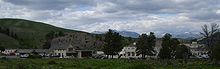
Fort Yellowstone, formerly a U.S. Army post,
now serves as park headquarters. |
.
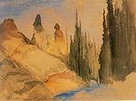 ... ...
Thomas Moran painted
Tower Creek, Yellowstone,
while on the Hayden
Geological Survey of 1871. |
During the 1870s and 1880s Native American tribes were
effectively excluded from the national park. A number of tribes had made
seasonal use of the Yellowstone area, but the only year-round residents
were small bands of Western Shoshone known as "Sheepeaters". They left
the area under the assurances of a treaty negotiated in 1868, under which
the Sheepeaters ceded their lands but retained the right to hunt in Yellowstone.
The United States never ratified the treaty and refused to recognize the
claims of the Sheepeaters or any other tribe that had made use of Yellowstone.
The Nez Perce band associated with Chief Joseph, numbering about 750 people,
passed through Yellowstone National Park in thirteen days during late August,
1877. They were being pursued by the U.S. Army and entered the national
park about two weeks after the Battle of the Big Hole. Some of the Nez
Perce were friendly to the tourists and other people they encountered in
the park, some were not. Nine park visitors were briefly taken captive.
Despite Joseph and other chiefs ordering that no one should be harmed,
at least two people were killed and several wounded. One of the areas where
encounters occurred was in Lower Geyser Basin and east along a branch of
the Firehole River to Marys Mountain and beyond. That stream is still known
as Nez Perce Creek. |
A group of Bannocks entered the park in 1878, alarming
park Superintendent Philetus Norris. In the aftermath of the Sheepeater
Indian War of 1889, Norris built a fort for the purpose of preventing Native
Americans from entering the national park.
Ongoing poaching and destruction of natural resources
continued unabated until the U.S. Army arrived at Mammoth Hot Springs in
1886 and built Camp Sheridan. Over the next 22 years the army constructed
permanent structures, and Camp Sheridan was renamed Fort Yellowstone. With
the funding and manpower necessary to keep a diligent watch, the army developed
their own policies and regulations that permitted public access while protecting
park wildlife and natural resources. When the National Park Service was
created in 1916, many of the management principles developed by the army
were adopted by the new agency. The army turned control over to the National
Park Service on October 31, 1918.
Later history
By 1915, 1,000 automobiles per year were entering the
park, resulting in conflicts with horses and horse driven transportation.
In subsequent years horse travel on roads was eventually prohibited. Between
1933 and 1941, the Civilian Conservation Corps built the majority of the
early visitor centers, campgrounds and the current system of park roads.
During World War II, staffing and visitation both decreased, and many facilities
fell into disrepair. By the 1950s, visitation increased tremendously in
Yellowstone and other national parks. To accommodate the increased visitation,
park officials implemented Mission 66, an effort to modernize and expand
park service facilities. Planned to be completed by 1966, in honor of the
50th anniversary of the founding of the National Park Service, Mission
66 construction diverged from the traditional log cabin style with design
features of a modern style. During the late 1980s, most construction styles
in Yellowstone reverted back to the more traditional designs. After the
enormous forest fires of 1988 damaged much of Grant Village, structures
there were rebuilt in the traditional style. The visitor center at Canyon
Village, which opened in 2006, incorporates a more traditional design as
well.
A large arch made of irregular-shaped natural stone over
a road
| The 1959 Yellowstone earthquake just west of Yellowstone
at Hebgen Lake damaged roads and some structures in the park. In the northwest
section of the park, new geysers were found, and many existing hot springs
became turbid. It was the most powerful earthquake to hit the region in
recorded history. In 1963, after several years of public controversy regarding
the forced reduction of the elk population in Yellowstone, United States
Secretary of the Interior Stewart Udall appointed an advisory board to
collect scientific data to inform future wildlife management of the national
parks. In a paper known as the Leopold Report, the committee observed that
culling programs at other national parks had been ineffective, and recommended
management of Yellowstone's elk population.
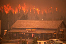
The wildfires during the summer of 1988 were the largest
in the history of the park. Approximately 793,880 acres (1,240 sq mi; 321,272
ha) or 36% of the parkland was impacted by the fires, leading to a systematic
reevaluation of fire management policies. The fire season of 1988 was considered
normal until a combination of drought and heat by mid-July contributed
to an extreme fire danger. On "Black Saturday," August 20, 1988, strong
winds expanded the fires rapidly, and more than 150,000 acres (61,000 ha;
230 sq mi) burned. |
.....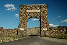 .... ....
The Roosevelt Arch is located in
Montana at the North Entrance.
The arch's cornerstone was laid
by Theodore Roosevelt.
The placard reads
"For the Benefit and Enjoyment of the People." |
The expansive cultural history of the park has been documented
by the 1,000 archeological sites that have been discovered. The park has
1,106 historic structures and features, and of these Obsidian Cliff and
five buildings have been designated National Historic Landmarks. Yellowstone
was designated an International Biosphere Reserve on October 26, 1976,
and a United Nations World Heritage Site on September 8, 1978.
Heritage & Research Center
The Heritage & Research Center is located at Gardiner,
Montana, near the north entrance to the park. The center is home to the
Yellowstone National Parks museum collection, archives, research library,
historian, archeology lab, and herbarium. The Yellowstone National Park
Archives maintain collections of historical records of Yellowstone and
the National Park Service. The collection includes the administrative records
of Yellowstone, the worlds first national park, as well as resource management
records, records from major projects as well as, donated manuscripts and
personal papers. The archives are affiliated with the National Archives
and Records Administration.
Geography
| Approximately 96 percent of the land area of Yellowstone
National Park is located within the state of Wyoming. Another 3 percent
is within Montana, with the remaining 1 percent in Idaho. The park is 63
miles (101 km) north to south, and 54 miles (87 km) west to east by air.
Yellowstone is 2,219,789 acres (898,317 ha; 3,468.420 sq mi) in area, larger
than the states of Rhode Island or Delaware. Rivers and lakes cover 5 percent
of the land area, with the largest water body being Yellowstone Lake at
87,040 acres (35,220 ha; 136.00 sq mi). Yellowstone Lake is up to 400 feet
(120 m) deep and has 110 miles (180 km) of shoreline. At an elevation of
7,733 feet (2,357 m) above sea level, Yellowstone Lake is the largest high
altitude lake in North America. Forests comprise 80 percent of the land
area of the park; most of the rest is grassland. |
..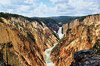
Grand Canyon of the Yellowstone.
Note the yellow color of the rocks
from which the park gets its name |
.
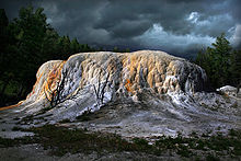 .. ..
A large whitish mound
Orange Spring Mound |
The Continental Divide of North America runs
diagonally through the southwestern part of the park. The divide is a topographic
feature that separates Pacific Ocean and Atlantic Ocean water drainages.
About one third of the park lies on the west side of the divide. The origins
of the Yellowstone and Snake Rivers are near each other but on opposite
sides of the divide. As a result, the waters of the Snake River flow to
the Pacific Ocean, while those of the Yellowstone find their way to the
Atlantic Ocean via the Gulf of Mexico.
The park sits on the Yellowstone Plateau, at an average
elevation of 8,000 feet (2,400 m) above sea level. The plateau is bounded
on nearly all sides by mountain ranges of the Middle Rocky Mountains, which
range from 9,000 to 11,000 feet (2,700 to 3,400 m) in elevation. The highest |
..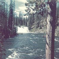 .. ..
Scenic views abound in
Yellowstone (1974 photograph) |
point in the park is atop Eagle Peak (11,358 ft/3,462 m)
and the lowest is along Reese Creek (5,282 ft/1,610 m). Nearby mountain
ranges include the Gallatin Range to the northwest, the Beartooth Mountains
in the north, the Absaroka Range to the east, and the Teton Range and the
Madison Range to the southwest and west. The most prominent summit on the
Yellowstone Plateau is Mount Washburn at 10,243 feet (3,122 m).
Yellowstone National Park has one of the world's largest
petrified forests, trees which were long ago buried by ash and soil and
transformed from wood to mineral materials. This ash and other volcanic
debris, are believed to have come from the park area itself. This is largely
due to the fact that Yellowstone is actually a massive caldera of a supervolcano.
There are 290 waterfalls of at least 15 feet (4.6 m) in the park, the highest
being the Lower Falls of the Yellowstone River at 308 feet (94 m).
Three deep canyons are located in the park, cut through
the volcanic tuff of the Yellowstone Plateau by rivers over the last 640,000
years. The Lewis River flows through Lewis Canyon in the south, and the
Yellowstone River has carved two colorful canyons, the Grand Canyon of
the Yellowstone and the Black Canyon of the Yellowstone in its journey
north.
Geology
| Yellowstone is at the northeastern end of the Snake River
Plain, a great U-shaped arc through the mountains that extends from Boise,
Idaho some 400 miles (640 km) to the west. This feature traces the route
of the North American Plate over the last 17 million years as it was transported
by plate tectonics across a stationary mantle hotspot. The landscape of
present-day Yellowstone National Park is the most recent manifestation
of this hotspot below the crust of the Earth.
The Yellowstone Caldera is the largest volcanic system
in North America. It has been termed a "supervolcano" because the caldera
was formed by exceptionally large explosive eruptions. The current caldera
was created by a cataclysmic eruption that occurred 640,000 years ago,
which released 240 cubic miles (1,000 km³) of ash, rock and pyroclastic
materials. This eruption was 1,000 times larger than the 1980 eruption
of Mount St. Helens. It produced a crater nearly a two thirds of a mile
(1 km) deep and 52 by 28 miles (84 by 45 km) in area and deposited the
Lava Creek Tuff, a welded tuff geologic formation. The most violent known
eruption, which occurred 2.1 million years ago, ejected 588 cubic miles
(2,450 km³) of volcanic material and created the rock formation known
as the Huckleberry Ridge Tuff and created the Island Park Caldera. A smaller
eruption ejected 67 cubic miles (280 km³) of material 1.2 million
years ago, forming the Henry's Fork Caldera and depositing the Mesa Falls
Tuff. |
..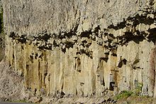
Columnar basalt near Tower Falls;
large floods of basalt and other lava types
preceded mega-eruptions of superheated
ash and pumice |
.
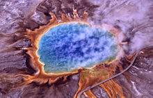 .. ..
Wooden walkways allow visitors to
closely approach the
Grand Prismatic Spring. |
Each of the three climax eruptions released vast amounts
of ash that blanketed much of central North America falling many hundreds
of miles away. The amount of ash and gases released into the atmosphere
probably caused significant impacts to world weather patterns and led to
the extinction of many species, primarily in North America.
A subsequent minor climax eruption occurred 160,000 years
ago. It formed the relatively small caldera that contains the West Thumb
of Yellowstone Lake. Later, two smaller eruptive cycles, the last one ending
about 70,000 years ago, buried much of the caldera under thick lava flows.
Each eruption is in fact a part of an eruptive cycle
that climaxes with the collapse of the roof of a partially emptied magma
chamber. This creates a crater, called a caldera, and releases vast amounts
of volcanic material, usually through fissures that ring the caldera. The
time between the last three cataclysmic eruptions in the Yellowstone area
has ranged from 600,000 to 900,000 years, but the small number of such
climax eruptions cannot be used to make a prediction for future volcanic
events. |
Between 630,000 and 700,000 years ago, Yellowstone Caldera
was nearly filled in with periodic eruptions of rhyolitic lavas such as
those that can be seen at Obsidian Cliffs and basaltic lavas which can
be viewed at Sheepeater Cliff. Lava strata are most easily seen at the
Grand Canyon of the Yellowstone, where the Yellowstone River continues
to carve into the ancient lava flows. The canyon is a classic V-shaped
valley, indicative of river-type erosion rather than erosion caused by
glaciation.
The most famous geyser in the park, and perhaps the world,
is Old Faithful Geyser, located in Upper Geyser Basin. Castle Geyser, Lion
Geyser and Beehive Geyser are in the same basin. The park contains the
largest active geyser in the worldSteamboat Geyser in the Norris Geyser
Basin. There are 300 geysers in Yellowstone and a total of at least 10,000
geothermal features altogether. Half the geothermal features and two-thirds
of the world's geysers are concentrated in Yellowstone.
In May 2001, the U.S. Geological Survey, Yellowstone National
Park, and the University of Utah created the Yellowstone Volcano Observatory
(YVO), a partnership for long-term monitoring of the geological processes
of the Yellowstone Plateau volcanic field, for disseminating information
concerning the potential hazards of this geologically active region.
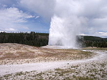 .. ..
Old Faithful Geyser erupts
approximately every 91 minutes. |
In 2003, changes at the Norris Geyser Basin resulted
in the temporary closure of some trails in the basin. New fumaroles were
observed, and several geysers showed enhanced activity and increasing water
temperatures. Several geysers became so hot that they were transformed
into purely steaming features; the water had become superheated and they
could no longer erupt normally. This coincided with the release of reports
of a multiple year United States Geological Survey research project which
mapped the bottom of Yellowstone Lake and identified a structural dome
that had uplifted at some time in the past. Research indicated that these
uplifts posed no immediate threat of a volcanic eruption, since they may
have developed long ago, and there had been no temperature increase found
near the uplifts. On March 10, 2004, a biologist discovered 5 dead bison
which apparently had inhaled toxic geothermal gases trapped in the Norris
Geyser Basin by a seasonal atmospheric inversion. This was closely followed
by an upsurge of earthquake activity in April 2004. In 2006, it was reported
that the Mallard Lake Dome and the Sour Creek Dome areas that have long
been known to show significant changes in their ground movement had risen
at a rate of 1.5 to 2.4 inches (3.8 to 6.1 cm) per year from mid2004 through
2006. As of late 2007, the uplift has continued at a reduced rate. These
events inspired a great deal of media attention and speculation about the
geologic future of the region. Experts responded to the conjecture by informing
the public that there was no increased risk of a volcanic eruption in the
near future. |
.
| Yellowstone experiences thousands of small earthquakes
every year, virtually all of which are undetectable to people. There have
been six earthquakes with at least magnitude 6 or greater in historical
times, including a 7.5 magnitude quake that struck just outside the northwest
boundary of the park in 1959. This quake triggered a huge landslide, which
caused a partial dam collapse on Hebgen Lake; immediately downstream, the
sediment from the landslide dammed the river and created a new lake, known
as Earthquake Lake. Twenty-eight people were killed, and property damage
was extensive in the immediate region. The earthquake caused some geysers
in the northwestern section of the park to erupt, large cracks in the ground
formed and emitted steam, and some hot springs' normally clear water turned
muddy. A 6.1 magnitude earthquake struck inside the park on June 30, 1975,
but damage was minimal. For three months in 1985, 3,000 minor earthquakes
were detected in the northwestern section of the park, during what has
been referred to as an earthquake swarm, and has been attributed to minor
subsidence of the Yellowstone caldera. Beginning on April 30, 2007, sixteen
small earthquakes with magnitudes up to 2.7 occurred in the Yellowstone
Caldera for several days. These swarms of earthquakes are common, and there
have been 70 such swarms between 1983 and 2008. In December 2008, over
250 earthquakes were measured over a four day span under Yellowstone Lake,
the largest measuring a magnitude of 3.9. In January 2010, more than 250
earthquakes were detected over a two day period. Seismic activity in Yellowstone
National Park continues and is reported hourly by the Earthquake Hazards
Program of the U.S. Geological Survey. |
..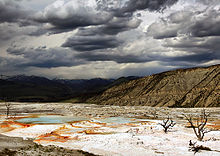
Upper Terraces of Mammoth Hot Springs |
.
| Biology and ecology
Yellowstone National Park is the centerpiece of the 20
million acre/31,250 square-mile (8,093,712 ha/80,937 km2) Greater Yellowstone
Ecosystem, a region that includes Grand Teton National Park, adjacent National
Forests and expansive wilderness areas in those forests. The ecosystem
is the largest remaining continuous stretch of mostly undeveloped pristine
land in the continental United States,considered to be the world's largest
intact ecosystem in the northern temperate zone (although the area is mostly
not temperate but subalpine, and all the national forest lands surrounding
the National Park are not intact). With the successful wolf reintroduction
program, which began in the 1990s, virtually all the original faunal species
known to inhabit the region when white explorers first entered the area
can still be found there. |
..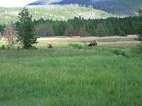
Mountain meadow at Yellowstone |
Flora
Over 1,700 species of trees and other vascular plants
are native to the park. Another 170 species are considered to be exotic
species and are non-native. Of the eight conifer tree species documented,
Lodgepole Pine forests cover 80% of the total forested areas. Other conifers,
such as Subalpine Fir, Engelmann Spruce, Rocky Mountain Douglas-fir and
Whitebark Pine, are found in scattered groves throughout the park. As of
2007, the whitebark pine is threatened by a fungus known as white pine
blister rust; however, this is mostly confined to forests well to the north
and west. In Yellowstone, about seven percent of the whitebark pine species
have been impacted with the fungus, compared to nearly complete infestations
in northwestern Montana. Quaking Aspen and willows are the most common
species of deciduous trees. The aspen forests have declined significantly
since the early 20th century, but scientists at Oregon State University
attribute recent recovery of the aspen to the reintroduction of wolves
which has changed the grazing habits of local elk.
| There are dozens of species of flowering plants that
have been identified, most of which bloom between the months of May and
September. The Yellowstone Sand Verbena is a rare flowering plant found
only in Yellowstone. It is closely related to species usually found in
much warmer climates, making the sand verbena an enigma. The estimated
8,000 examples of this rare flowering plant all make their home in the
sandy soils on the shores of Yellowstone Lake, well above the waterline.
In Yellowstone's hot waters, bacteria form mats of bizarre
shapes consisting of trillions of individuals. These bacteria are some
of the most primitive life forms on earth. Flies and other arthropods live
on the mats, even in the middle of the bitterly cold winters. Initially,
scientists thought that microbes there gained sustenance only from sulfur.
In 2005, researchers from the University of Colorado at Boulder discovered
that the sustenance for at least some of the diverse hyperthermophilic
species is molecular hydrogen. |
..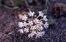
Yellowstone sand verbena are endemic
to the Yellowstone's lakeshores. |
Thermus aquaticus is a bacterium found in the Yellowstone
hot springs produces an important enzyme that is easily replicated in the
lab and is useful in replicating DNA as part of the polymerase chain reaction
(PCR) process. The retrieval of these bacteria can be achieved with no
impact to the ecosystem. Other bacteria in the Yellowstone hot springs
may also prove useful to scientists who are searching for cures for various
diseases.
Non-native plants sometimes threaten native species by
using up nutrient resources. Though exotic species are most commonly found
in areas with the greatest human visitation, such as near roads and at
major tourist areas, they have also spread into the backcountry. Generally,
most exotic species are controlled by pulling the plants out of the soil
or by spraying, both of which are time consuming and expensive.
Fauna
| Yellowstone is widely considered to be the finest megafauna
wildlife habitat in the lower 48 states. There are almost 60 species of
mammals in the park, including the endangered gray wolf, the threatened
lynx, and grizzly bears. Other large mammals include the bison (buffalo),
black bear, elk, moose, mule deer, white-tailed deer, mountain goat, pronghorn,
bighorn sheep and mountain lion.
The relatively large bison populations are a concern for
ranchers, who fear that the species can transmit bovine diseases to their
domesticated cousins. In fact, about half of Yellowstone's bison have been
exposed to brucellosis, a bacterial disease that came to North America
with European cattle that may cause cattle to miscarry. The disease has
little effect on park bison, and no reported case of transmission from
wild bison to domestic livestock has been filed. However, the Animal and
Plant Health Inspection Service (APHIS) has stated that Bison are the "likely
source" of the spread of the disease in cattle in Wyoming and North Dakota.
Elk also carry the disease and are believed to have transmitted the infection
to horses and cattle. Bison once numbered between 30 and 60 million individuals
throughout North America, and Yellowstone remains one of their last strongholds.
Their populations had increased from less than 50 in the park in 1902 to
4,000 by 2003. The park's bison population reached a peak in 2005 with
4,900 animals. Despite a summer estimated population of 4,700 in 2007,
the number dropped to 3,000 in 2008 after a harsh winter and controversial
brucellosis management sending hundreds to slaughter. The Yellowstone herd
is believed to be one of only four free roaming and genetically pure herds
on public lands in North America. The other three herds are in the Henry
Mountains of Utah, Wind Cave National Park in South Dakota and on Elk Island
in Alberta, Canada. |
..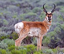
Pronghorn are commonly found
on the grasslands in the park.
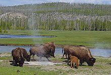
Bison graze near a hot spring
|
To combat the perceived threat, national park personnel
regularly harass bison herds back into the park when they venture outside
of the area's borders. During the winter of 199697, the bison herd was
so large that 1,079 bison that had exited the park were shot or sent to
slaughter. Animal rights activists argue that this is a cruel practice
and that the possibility for disease transmission is not as great as some
ranchers maintain. Ecologists point out that the bison are merely traveling
to seasonal grazing areas that lie within the Greater Yellowstone Ecosystem
that have been converted to cattle grazing, some of which are within National
Forests and are leased to private ranchers. APHIS has stated that with
vaccinations and other means, brucellosis can be eliminated from the bison
and elk herds throughout Yellowstone.
Starting in 1914, in an effort to protect elk populations,
the U.S. Congress appropriated funds to be used for the purposes of "destroying
wolves, prairie dogs, and other animals injurious to agriculture and animal
husbandry" on public lands. Park Service hunters carried out these orders,
and by 1926 they had killed 136 wolves, and wolves were virtually eliminated
from Yellowstone. Further exterminations continued until the National Park
Service ended the practice in 1935. With the passing of the Endangered
Species Act in 1973, the wolf was one of the first mammal species listed.
After the wolves were extirpated from Yellowstone, the coyote then became
the park's top canine predator. However, the coyote is not able to bring
down large animals, and the result of this lack of a top predator on these
populations was a marked increase in lame and sick megafauna.
| By the 1990s, the Federal government had reversed its
views on wolves. In a controversial decision by the U.S. Fish and Wildlife
Service (which oversees threatened and endangered species), Mackenzie Valley
wolves, imported from Canada, were reintroduced into the park. Reintroduction
efforts have been successful with populations remaining relatively stable.
A survey conducted in 2005 reported that there were 13 wolf packs, totaling
118 individuals in Yellowstone and 326 in the entire ecosystem. These park
figures were lower than those reported in 2004 but may be attributable
to wolf migration to other nearby areas as suggested by the substantial
increase in the Montana population during that interval. Almost all the
wolves documented were descended from the 66 wolves reintroduced in 199596.
The
recovery of populations throughout the states of Wyoming, Montana and Idaho
has been so successful that on February 27, 2008 the U.S. Fish and Wildlife
Service removed the Northern Rocky Mountain wolf population from the endangered
species list. |
..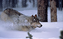
A reintroduced gray wolf in
Yellowstone National Park |
An estimated 600 grizzly bears live in the Greater Yellowstone
Ecosystem, with more than half of the population living within Yellowstone.
The grizzly is currently listed as a threatened species, however the U.S.
Fish and Wildlife Service has announced that they intend to take it off
the endangered species list for the Yellowstone region but will likely
keep it listed in areas where it has not yet recovered fully. Opponents
of delisting the grizzly are concerned that states might once again allow
hunting and that better conservation measures need to be implemented to
ensure a sustainable population.
Population figures for elk are in excess of 30,000the
largest population of any large mammal species in Yellowstone. The northern
herd has decreased enormously since the mid-1990s; this has been attributed
to wolf predation and causal effects such as elk using more forested regions
to evade predation, consequently making it harder for researchers to accurately
count them. The northern herd migrates west into southwestern Montana in
the winter. The southern herd migrates southward, and the majority of these
elk winter on the National Elk Refuge, immediately southeast of Grand Teton
National Park. The southern herd migration is the largest mammalian migration
remaining in the U.S. outside of Alaska.
In 2003, the tracks of one female lynx and her cub were
spotted and followed for over 2 miles (3.2 km). Fecal material and other
evidence obtained were tested and confirmed to be those of a lynx. No visual
confirmation was made, however. Lynx have not been seen in Yellowstone
since 1998, though DNA taken from hair samples obtained in 2001 confirmed
that lynx were at least transient to the park. Other less commonly seen
mammals include the mountain lion and wolverine. The mountain lion has
an estimated population of only 25 individuals parkwide. The wolverine
is another rare park mammal, and accurate population figures for this species
are not known. These uncommon and rare mammals provide insight into the
health of protected lands such as Yellowstone and help managers make determinations
as to how best to preserve habitats.
Eighteen species of fish live in Yellowstone, including
the core range of the Yellowstone cutthroat trouta fish highly sought
by anglers. The Yellowstone cutthroat trout has faced several threats since
the 1980s, including the suspected illegal introduction into Yellowstone
Lake of lake trout, an invasive species which consume the smaller cutthroat
trout. Although lake trout were established in Shoshone and Lewis lakes
in the Snake River drainage from U.S. Government stocking operations in
1890, it was never officially introduced into the Yellowstone River drainage.
The cutthroat trout has also faced an ongoing drought, as well as the accidental
introduction of a parasitewhirling diseasewhich causes a terminal nervous
system disease in younger fish. Since 2001, all native sport fish species
caught in Yellowstone waterways are subject to a catch and release law.[84]
Yellowstone is also home to six species of reptiles, such as the painted
turtle and Prairie rattlesnake, and four species of amphibians, including
the Boreal Chorus Frog.
311 species of birds have been reported, almost half of
which nest in Yellowstone. As of 1999, twenty-six pairs of nesting bald
eagles have been documented. Extremely rare sightings of whooping cranes
have been recorded, however only three examples of this species are known
to live in the Rocky Mountains, out of 385 known worldwide. Other birds,
considered to be species of special concern because of their rarity in
Yellowstone, include the common loon, harlequin duck, osprey, peregrine
falcon and the trumpeter swan.
Forest fires
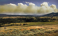 .. ..
Wildfire in Yellowstone National Park
produces Pyrocumulus cloud |
Wildfire is a natural part of most ecosystems, and plants
found in Yellowstone have adapted in a variety of ways. Douglas-fir has
a thick bark which protects the inner section of the tree from most fires.
Lodgepole Pines the most common tree species in the park generally have
cones that are only opened by the heat of fire. Their seeds are held in
place by a tough resin, and fire assists in melting the resin, allowing
the seeds to disperse. Fire clears out dead and down wood, providing fewer
obstacles for lodgepole pines to flourish. Subalpine Fir, Engelmann Spruce,
Whitebark Pine and other species tend to grow in colder and moister areas,
where fire is less likely to occur. Aspen trees sprout new |
..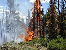
Fire in Yellowstone National Park |
growth from their roots, and even if a severe fire
kills the tree above ground, the roots often survive unharmed because they
are insulated from the heat by soil.] The National Park Service estimates
that in natural conditions, grasslands in Yellowstone burned an average
of every 20 to 25 years, while forests in the park would experience fire
about every 300 years.
About thirty-five natural forest fires are ignited each
year by lightning, while another six to ten are started by people in most
cases by accident. Yellowstone National Park has three fire towers, each
staffed by trained fire fighters. The easiest one to reach is atop Mount
Washburn, though it is closed to the public. The park also monitors fire
from the air and relies on visitor reports of smoke and or flames. Fire
towers are staffed almost continuously from late June to mid-September
the primary fire season. Fires burn with the greatest intensity in the
late afternoon and evening. Few fires burn more than 100 acres (40 ha),
and the vast majority of fires reach only a little over an acre (0.5 ha)
before they burn themselves out. Fire management focuses on monitoring
dead and down wood quantities, soil and tree moisture, and the weather,
to determine those areas most vulnerable to fire should one ignite. Current
policy is to suppress all human caused fires and to evaluate natural fires,
examining the benefit or detriment they may pose on the ecosystem. If a
fire is considered to be an immediate threat to people and structures,
or will burn out of control, then fire suppression is performed.
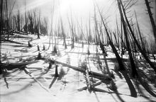 .. ..
Fire damage to trees giving way to
new growth in Yellowstone |
In an effort to minimize the chances of out of control
fires and threats to people and structures, park employees do more than
just monitor the potential for fire. Controlled burns are prescribed fires
which are deliberately started to remove dead timber under conditions which
allow fire fighters an opportunity to carefully control where and how much
wood is consumed. Natural fires are sometimes considered prescribed fires
if they are left to burn. In Yellowstone, unlike some other parks, there
have been very few fires deliberately started by employees as prescribed
burns. However, over the last 30 years, over 300 natural fires have been
allowed to burn naturally. In addition, fire fighters remove dead and down
wood and other hazards from areas where they will be a potential fire threat
to lives and property, reducing the chances of fire danger in these areas.
Fire monitors also regulate fire through educational services to the public
and have been known to temporarily ban campfires from campgrounds during
periods of high fire danger. The common notion in early United States land
management policies was that all forest fires were bad. Fire was seen as
a purely destructive force and there was little understanding that it was
an integral part of the ecosystem. Consequently, until the 1970s, when
a better understanding of wildfire was developed, all fires were suppressed.
This led to an increase in dead and dying forests, which would later provide
the fuel load for fires that would be much harder, and in some cases, impossible
to control. Fire Management Plans were implemented, detailing that natural
fires should be allowed to burn if they posed no immediate threat to lives
and property. |
| 1988 started with a wet spring season although by summer,
drought began moving in throughout the northern Rockies, creating the driest
year on record to that point, courtesy of the droughts of 1988 and 1989.
Grasses and plants which grew well in the early summer from the abundant
spring moisture produced plenty of grass, which soon turned to dry tinder.
The National Park Service began firefighting efforts to keep the fires
under control, but the extreme drought made suppression difficult. Between
July 15 and July 21, 1988, fires quickly spread from 8,500 acres (3,400
ha; 13.3 sq mi) throughout the entire Yellowstone region, which included
areas outside the park, to 99,000 acres (40,000 ha; 155 sq mi) on the park
land alone. By the end of the month, the fires were out of control. Large
fires burned together, and on August 20, 1988, the single worst day of
the fires, more than 150,000 acres (61,000 ha; 230 sq mi) were consumed.
Seven large fires were responsible for 95% of the 793,000 acres (321,000
ha; 1,239 sq mi) that were burned over the next couple of months. A total
of 25,000 firefighters and U.S. military forces participated in the suppression
efforts, at a cost of 120 million dollars. By the time winter brought snow
that helped extinguish the last flames, the fires had destroyed 67 structures
and caused several million dollars in damage. Though no civilian lives
were lost, two personnel associated with the firefighting efforts were
killed. |
A crown fire approaches the Old Faithful
complex on September 7, 1988 |
Contrary to media reports and speculation at the time,
the fires killed very few park animals surveys indicated that only about
345 elk (of an estimated 40,00050,000), 36 deer, 12 moose, 6 black bears,
and 9 bison had perished. Changes in fire management policies were implemented
by land management agencies throughout the U.S., based on knowledge gained
from the 1988 fires and the evaluation of scientists and experts from various
fields. By 1992, Yellowstone had adopted a new fire management plan which
observed stricter guidelines for the management of natural fires.
Climate
| Yellowstone climate is greatly influenced
by altitude, with lower elevations generally found to be warmer year round.
The record high temperature was 99 °F (37 °C) in 2002, while the
coldest temperature recorded is ?66 °F (?54.4 °C) in 1933. During
the summer months of June through early September, daytime highs are normally
in the 70 to 80 °F (21 to 27 °C) range, while nighttime lows can
go to below freezing (0 °C)especially at higher altitudes. Summer
afternoons are frequently accompanied by thunderstorms. Spring and fall
temperatures range between 30 and 60 °F (-1 and 16 °C) with cold
nights in the teens to single digits (-5 to -20 °C). Winter in Yellowstone
is very cold with high temperatures usually between zero to 20 °F (-20
to -5 °C) and nighttime temperatures below zero °F (-20 °C)
for most of the winter.
Precipitation in Yellowstone is highly variable and ranges
from 15 inches (380 mm) annually near |
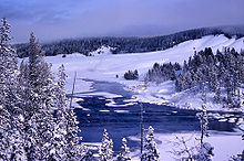
Winter scene in Yellowstone |
Mammoth Hot Springs, to 80 inches (2,000 mm) in the southwestern
sections of the park. The precipitation of Yellowstone is greatly influenced
by the moisture channel formed by the Snake River Plain to the west that
was, in turn, formed by Yellowstone itself. Snow is possible in any month
of the year, with averages of 150 inches (3,800 mm) annually around Yellowstone
Lake, to twice that amount at higher elevations.
Tornadoes in Yellowstone are rare; however, on July 21,
1987, the most powerful tornado recorded in Wyoming touched down in the
Teton Wilderness of Bridger-Teton National Forest and hit Yellowstone National
Park. Called the TetonYellowstone tornado, it was classified as an F4,
with wind speeds estimated at between 207 and 260 miles per hour (333 and
418 km/h). The tornado left a path of destruction 1 to 2 miles (1.6 to
3.2 km) wide, and 24 miles (39 km) long, and leveled 15,000 acres (6,100
ha; 23 sq mi) of mature pine forest.
Recreation
| Yellowstone is one of the most popular national
parks in the United States. Since the mid-1960s, at least 2 million tourists
have visited the park almost every year. At peak summer levels, 3,700 employees
work for Yellowstone National Park concessionaires. Concessionaires manage
nine hotels and lodges, with a total of 2,238 hotel rooms and cabins available.
They also oversee gas stations, stores and most of the campgrounds. Another
800 employees work either permanently or seasonally for the National Park
Service.
Park service roads lead to major features; however, road
reconstruction has produced temporary road closures. Yellowstone is in
the midst of a long term road reconstruction effort, which is hampered
by a short repair season. In the winter, all roads aside from the one which
enters from Gardiner, Montana, and extends to Cooke City, Montana, are
closed to wheeled vehicles.[98] Park roads are closed to wheeled vehicles
from early November to mid April, but some park roads remain closed until
mid-May. The park has 310 miles (500 km) of paved roads which can be accessed
from 5 different entrances. There is no public transportation available
inside the park, but several tour companies can be contacted for guided
motorized transport. In the winter, concessionaires operate guided snowmobile
and snow coach tours. Facilities in the Old Faithful, Canyon and Mammoth
Hot Springs areas of the park are very busy during the summer months. Traffic
jams created by road construction or by people observing wildlife can result
in long delays.
|
..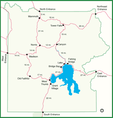
Orientation map of Yellowstone
National Park showing many of the
major tourist attractions |
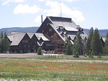 .. ..
Old Faithful Inn |
The National Park Service maintains 9 visitor
centers and museums and is responsible for maintenance of historical structures
and many of the other 2,000 buildings. These structures include National
Historical Landmarks such as the Old Faithful Inn built in 190304 and
the entire Fort Yellowstone - Mammoth Hot Springs Historic District. An
historical and educational tour is available at Fort Yellowstone which
details the history of the National Park Service and the development of
the park. Campfire programs, guided walks and other interpretive presentations
are available at numerous locations in the summer, and on a limited basis
during other seasons. |
...jpg)
Union Pacific Railway Brochure
Promoting Travel to Park (1921) |
Camping is available at a dozen campgrounds with more
than 2,000 campsites. Camping is also available in surrounding National
Forests, as well as in Grand Teton National Park to the south. Backcountry
campsites are accessible only by foot or by horseback and require a permit.
There are 1,100 miles (1,800 km) of hiking trails available. The park is
not considered to be a good destination for mountaineering because of the
instability of volcanic rock which predominates. Visitors with pets are
required to keep them on a leash at all times and are limited to areas
near roadways and in "frontcountry" zones such as drive in campgrounds.
Around thermal features, wooden and paved trails have been constructed
to ensure visitor safety, and most of these areas are handicapped accessible.
The National Park Service maintains a year round clinic at Mammoth Hot
Springs and provides emergency services throughout the year.
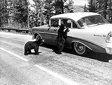 .. ..
Vintage photo of visitors feeding
bears in spite of the danger |
Hunting is not permitted, though it is allowed
in the surrounding national forests during season. Fishing is a popular
activity, and a Yellowstone Park fishing license is required to fish in
park waters. Many park waters are fly fishing only and all native fish
species are catch and release only. Boating is prohibited on rivers and
creeks except for a 5 miles (8.0 km) stretch of the Lewis River between
Lewis and Shoshone Lake, and it is open to non-motorized use only. Yellowstone
Lake has a marina, and the lake is the most popular boating destination. |
..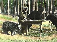
Park Superintendent
Horace M. Albright
and dinner guests, 1922 |
| In the early history of the park, visitors were allowed,
and sometimes even encouraged, to feed the bears. The bears had learned
to beg for food, and visitors welcomed the chance to get their pictures
taken with them. This led to numerous injuries to humans each year. In
1970, park officials changed their policy and started a vigorous program
to educate the public on the dangers of close contact with bears, and to
try to eliminate opportunities for bears to find food in campgrounds and
trash collection areas. Although it has become more difficult to observe
them in recent years, the number of human injuries and deaths has taken
a significant drop and visitors are in less danger.
Other protected lands in the region include Caribou-Targhee,
Gallatin, Custer, Shoshone and Bridger-Teton National Forests. The National
Park Service's John D. Rockefeller, Jr. Memorial Parkway is to the south
and leads to Grand Teton National Park. The famed Beartooth Highway provides
access from the northeast and has spectacular high altitude scenery. Nearby
communities include West Yellowstone, Montana; Cody, Wyoming; Red Lodge,
Montana; Ashton, Idaho; and Gardiner, Montana. The closest air transport
is available by way of Bozeman; Billings, Montana; Jackson; Cody, Wyoming
or Idaho Falls, Idaho.[108] Salt Lake City, 320 miles (510 km) to the south,
is the closest large metropolitan area. |
..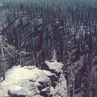
Yellowstone tourist stands on a
precipice for a close-up view
of the scenery. (1974 photograph) |
|