| Death Valley From Wikipedia, the free encyclopedia
Death Valley is a desert located in the southwestern United
States. It is the lowest, driest, and hottest location in North America.
Badwater, a basin located within Death Valley, is the specific location
of the lowest elevation in North America at 282 ft (85.5 m ) below sea
level. This point is only 76 miles (123 km) east of Mount Whitney, the
highest point in the contiguous United States. Death Valley holds the record
for the highest reliably reported temperature in the Western hemisphere,
134°F (56.7°C) at Furnace Creek in 1913just short of the world
record, which was 136°F (58°C) in Al 'Aziziyah, Libya, on September
13, 1922.
Located on the border between California and Nevada, in
the Great Basin and the Mojave Desert, southeast of the Sierra Nevada mountains,
Death Valley constitutes much of Death Valley National Park and is the
principal feature of the Mojave and Colorado Deserts Biosphere Reserve.
It is located mostly in Inyo County, California. It runs from north to
south between the Amargosa Range on the east and the Panamint Range on
the west; the Sylvania Mountains and the Owlshead Mountains form its northern
and southern boundaries, respectively. It has an area of about 3,000 sq
mi (7,800 km2). Death Valley shares many characteristics with other places
around the world that lie below sea level.
Geology
Death Valley is one of the best geological examples of
a basin and range configuration. It lies at the southern end of a geological
trough known as Walker Lane, which runs north into Oregon. The valley is
bisected by a right lateral strike slip fault system, represented by the
Death Valley Fault and the Furnace Creek Fault. The eastern end of the
left lateral Garlock Fault intersects the Death Valley Fault. Furnace Creek
and the Amargosa River flow through the valley but eventually disappear
into the sands of the valley floor.
Death Valley also contains salt pans. According to current
geological consensus, during the middle of the Pleistocene era there was
a succession of inland seas (collectively referred to as Lake Manly) located
where Death Valley is today. As the area turned to desert the water evaporated,
leaving behind the abundance of evaporitic salts such as common sodium
salts and borax, which were subsequently exploited during the modern history
of the region, primarily 1883 to 1907.
As a general rule, lower altitudes tend to have higher
temperatures where the sun heats the ground and that heat is then radiated
upward, but as the air begins to rise it is trapped by (1) the surrounding
elevation and (2) the weight of the air (essentially the atmospheric pressure)
above it. The atmospheric pressure is higher at very low altitudes than
it is under the same conditions at sea level because there is more air
(more distance) between the ground and the top of the atmosphere. This
pressure traps the heat near the ground, and also creates wind currents
that circulate very hot air, thereby distributing the heat to all areas,
regardless of shade and other factors.
This process is especially important in Death Valley as
it provides its specific climate and geography. The valley is surrounded
by mountains, while its surface is mostly flat and devoid of plants, and
of which a high percentage of the sun's heat is able to reach the ground,
absorbed by soil and rock. When air at ground level is heated, it begins
to rise, moving up pass steep high mountain ranges, which then cools slightly
sinking back down towards the valley more compressed. This air is then
reheated by the sun to a higher temperature moving up the mountain again,
whereby the air moves up and down in a circular motion in cycles similar
to how a convection oven works, albeit a natural one. This superheated
air increases ground temperature markedly, forming the hot wind currents
that are trapped by atmospheric pressure and mountains thus stays mostly
within the valley. Such hot wind currents contribute to perpetual drought
like conditions in Death Valley and prevent much cloud formation to pass
through the confines of the valley, where precipitation is often in the
form of a virga. Death Valley holds temperature records because it has
an unusually high number of factors that lead to high atmospheric temperatures.
Climate
The depth and shape of Death Valley influence its summer
temperatures. The valley is a long, narrow basin 282 feet (86 m) below
sea level, yet is walled by high, steep mountain ranges. The clear, dry
air and sparse plant cover allow sunlight to heat the desert surface. Heat
radiates back from the rocks and soil, then becomes trapped in the valley's
depths. Summer nights provide little relief as overnight lows may only
dip into the 86°F to 95°F (30°C to 35°C) range. Heated
air rises, yet is trapped by the high valley walls, is cooled and recycled
back down to the valley floor. These pockets of descending air are only
slightly cooler than the surrounding hot air. As they descend, they are
compressed and heated even more by the low elevation air pressure. These
moving masses of super heated air blow through the valley creating extreme
high temperatures.
The hottest air temperature ever recorded in Death Valley
(Furnace Creek) was 134°F (57°C) on July 10, 1913, also that same
year saw Death Valley's coldest temperature, on January 8 the temperature
dropped to 67°F (20°C) at Furnace Creek. During the heat wave that
peaked with that record, five consecutive days reached 129° F (54°C)
or above. The greatest number of consecutive days with a maximum temperature
of 100° F or above was 154 days in the summer of 2001. The summer of
1996 had 40 days over 120° F, and 105 days over 110° F.
................................................................................................................................................................................. |
During very wet periods, such as the winter of 1995,
the Amargosa River can flow at the surface, even forming a temporary lake
at Badwater. |
The summer of 1917 had 52 days where temperatures reached
120° F (49°C) or above with 43 of them consecutive. Four major
mountain ranges lie between Death Valley and the ocean, each one adding
to an increasingly drier rainshadow effect, and in 1929 and 1953 no rain
was recorded for the whole year. The period from 1931 to 1934 was the driest
stretch on record with only 0.64 inches (1.6cm) of rain over a 40-month
period.
From 1961-2008 the weather station at Death Valley (Furnace
Creek) recorded an average yearly temperature of 76.7°F (24.8°C)
with an average high in January of around 66°F (19°C) and 116°F
(47°C) in July. However another weather station located in Death Valley
(Cow Creek), during the period from 1934 to 1961 recorded an average yearly
temperature of 77.3°F (25.2°C) with an average high in January
of around 64°F (18°C) and 116°F (47°C) in July.
The period from July 17-19, 1959 was the longest string
of consecutive days where night time low temperatures did not drop below
100°F. As recently as 2003 the Furnace Creek weather station reported
two consecutive readings with night time lows of 100°F or above. The
highest ever night time low temperature in Death Valley was 103°F recorded
on July 5, 1970 and July 24, 2003.
The longest stretch of consecutive days where temperatures
reached 90°F (32°C) or more was 205 during Apr-Oct 1992. On average
there are 192 days per year in Death Valley where temperatures reach 90°F
(32°C) or more.
The average annual precipitation in Death valley (Greenland
Ranch Station) is 1.58 inches (4.00 cm). The wettest month on record is
January 1995 when 2.59 inches (6.57 cm) fell on Death Valley.
Weather averages for Death Valley (Furnace Creek Station)
Temperatures in Fahrenheit
| Month |
Jan |
Feb |
Mar |
Apr |
May |
Jun |
Jul |
Aug |
Sep |
Oct |
Nov |
Dec |
Year |
| Record high |
98 |
107 |
109 |
118 |
122 |
128 |
134 |
125 |
123 |
113 |
109 |
102 |
134 |
| Average high |
72.1 |
73.5 |
81.3 |
89.8 |
109.7 |
119.4 |
125.8 |
117.9 |
108.9 |
106.3 |
90.8 |
89.1 |
90.9 |
| Average low |
70.3 |
76.0 |
83.9 |
91.6 |
101.7 |
110.8 |
120.5 |
115.5 |
114.0 |
110.8 |
107.9 |
87.0 |
87.0 |
| Record low |
67 |
70 |
76 |
85 |
95 |
110 |
118 |
111 |
108 |
102 |
92 |
76 |
67 |
| Precipitation inches |
.35 |
.42 |
.42 |
.12 |
.10 |
.05 |
.11 |
.14 |
.19 |
.13 |
.12 |
.18 |
2.33 |
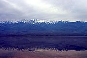
Lake Badwater and Glacial Lake Manly
| In 2005, Death Valley received 4 times its
average annual rainfall of 1.5 inches. As it has done before for hundreds
of years, the lowest spot in the valley filled with a wide, shallow lake,
but the extreme heat and aridity immediately began sucking the ephemeral
lake dry.
This pair of images from NASAs Landsat 5 satellite documents
the short history of Death Valleys Lake Badwater: formed in February 2005
(top) and long gone by February 2007 (bottom). In 2005, a big pool of greenish
water stretched most of the way across the valley floor. By May of 2005
the valley floor had resumed its more familiar role as Badwater, a salt-coated
playa. In time, this freshly dissolved and recrystallized salt will darken.
The western margin of Death Valley is traced by alluvial
fans. During flash floods, rainfall from the steep mountains to the west
pours through narrow canyons, picking up everything from fine clay to large
rocks. When these torrents reach the mouths of the canyons, they widen
and slow, branching out into braided streams. The paler the fans, the younger
they are.
During the Pleistocene ice age, which ended roughly 10,000-12,000
years ago, the Sierra Nevada ranges were much wetter. During that time,
Death Valley was filled with a huge lake, called Glacial Lake Manly, that
was nearly 100 miles long and 600 feet deep.
History
Death Valley is home to the Timbisha tribe of Native Americans,
formerly known as the Panamint Shoshone, who have inhabited the valley
for at least the past 1000 years. The Timbisha name for the valley, tümpisa,
means "rock paint" and refers to the red ochre paint that can be made from
a type of clay found in the valley. Some families still live in the valley
at Furnace Creek. Another village was located in Grapevine Canyon near
the present site of Scotty's Castle. It was called maahunu in the Timbisha
language, the meaning of which is uncertain, although it is known that
hunu is "canyon".................................................................................................................................................................. |
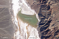
Lake Badwater, February 9, 2005. Landsat 5 satellite
photo. |
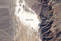
Badwater dry lake, February 15, 2007. Landsat 5 satellite
photo. |
|
The valley received its English name in 1849 during the
California Gold Rush. It was called Death Valley by prospectors and others
who sought to cross the valley on their way to the gold fields, even though
only one death in the area was recorded during the Rush. During the 1850s,
gold and silver were extracted in the valley. In the 1880s, borax was discovered
and extracted by mule-drawn wagons.
Death Valley National Monument was proclaimed on February
11, 1933 by President Hoover, placing the area under federal protection.
In 1994, the monument was redesignated as Death Valley National Park, as
well as being substantially expanded to include Saline and Eureka Valleys.
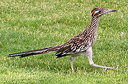
Greater Roadrunner at Death Valley National Park Visitor
Center, California |
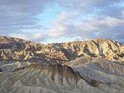
Zabriskie Point at sunrise in Death Valley. |
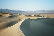
Sand dunes in Death Valley |
|
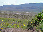
Sometimes after winter rains, Death Valley does not look
like a desert for a few weeks. |
|
More information http://en.wikipedia.org/wiki/Death_Valley_National_Park
|